
Colchester Submission Draft Local Plan Regulation 19 Consultation 2026
2. Vision and approach to Local Plan Comment
Approach to the Local Plan
2.1Section 19(1A) of the Planning and Compulsory Purchase Act 2004 requires local planning authorities to include in their Local Plans ‘policies designed to secure that the development and use of land in the local planning authority’s area contribute to the mitigation of, and adaptation to, climate change’. This statutory requirement underpins the overall strategy for the Local Plan and aligns with national policy, which requires plans to contribute to the achievement of sustainable development.
2.2The way places are planned, designed and built can have a significant influence on health and wellbeing. All development should be designed to provide opportunities for healthy lifestyles and contribute to the creation of healthy, inclusive communities, and help to reduce health inequalities for people of all ages and abilities through placemaking. The Council will continue to work with partners and health providers to improve and promote healthier and active lifestyles for our residents and communities. Health and wellbeing outcomes are embedded throughout the Local Plan and reflected in policies.
2.3The Local Plan takes a holistic and integrated approach to achieving sustainable development, addressing the climate emergency, biodiversity and the environment, health and wellbeing and the cost of living crisis. All policies individually and cumulatively have been considered in this context.
2.4The Environment Act 2021 introduces a strengthened statutory duty to conserve and enhance biodiversity. The Act establishes a strengthened biodiversity duty on public authorities, which states that public authorities must consider what they can do to conserve and enhance biodiversity and have regard to Local Nature Recovery Strategies when creating local plans and making planning decisions.
2.5Protecting and enhancing biodiversity, nature recovery and addressing the climate emergency are not stand-alone issues, they are intertwined and embedded in all aspects of planning. A key purpose of the Local Plan has been to enhance Colchester’s green network and waterways and incorporate the numerous themes of the planning for a better environment agenda, such as air quality, biodiversity net gain, climate change adaptation and mitigation and net zero, flooding and coastal erosion, green and blue infrastructure, greenspace provision, Habitat Regulations, Local Nature Recovery Strategy, natural capital and environmental net gain, protected sites and species and water quality and resources.
2.6The effects of climate change are already being experienced – more storms and heavy rainfall coupled with water stress, heatwaves and higher temperatures. The Local Plan therefore includes policy requirements to support the transition to net zero homes and buildings, alongside climate change mitigation and adaptation measures.
2.7Essex is the most water stressed county in the country. The situation is expected to get worse due to climate change, population growth and the need to restore, protect and enhance the natural environment. Although Essex is one of the driest places in the country, there are also areas at very high flood risk from the sea, rivers and rainfall. In addition to this, water quality in Essex is below the national average as a result of storm overflows discharging sewage into the water supply; pollution from fertilisers and poor livestock management; and runoff from construction and traffic.
2.8The climate emergency and ecological emergency are closely related. As the climate changes, nature changes. The State of Nature Report 2023 says that the UK, like most other countries worldwide, has seen significant loss of its plants, animals and fungi. The UK is now one of the most nature-depleted countries on Earth. Across the UK, species studied have declined on average by 19% since 1970, nearly one in six species are threatened with extinction from Great Britain, and 151 of 10,008 species assessed have already become extinct since 1500.
2.9The Local Plan has been prepared alongside the Essex Local Nature Recovery Strategy (LNRS), which has provided evidence of the actions to reverse the current path of decline and bring about a recovery for nature. The LNRS identifies locations to create or improve habitat most likely to provide the greatest benefit for nature and the wider environment.
2.10The Essex LNRS explains that 'Essex, like the whole of the UK, has suffered extreme biodiversity loss in the last 50 years, with many habitats and species now vulnerable or seriously threatened. Once common species in our county such as Turtle Doves, European Eels and Hedgehogs are now seriously depleted and at risk. Habitats are now left largely fragmented and isolated, causing significant declines in biodiversity and ecological quality. Human life, too, is affected by these changes.' The Local Plan aims to play a role in nature recovery across Colchester.
2.11Nature contributes much value through natural capital. Ecosystem services provide a regulating, provisioning and cultural role. Over the long term, the economic costs of failing to address the climate emergency and biodiversity loss, will be higher through loss of natural capital than the costs of addressing them now.
2.12The Essex Climate Action Commission recognise that the natural world is our best ally in reversing climate change – it is key to absorbing and storing carbon. Risks from already changing weather systems: more flooding, over-heating, soil degradation, subsidence and water shortage can be tackled by making space for open spaces and nurturing our natural world. Through declaring a climate emergency, it has become a priority of Colchester City Council to spur urgent action to reduce our carbon footprint and promote sustainable development. This priority is incorporated throughout the Local Plan.
2.13 The green network plays a critical role in delivering environmental, social and health benefits. The Essex LNRS includes a target to double the amount of natural greenspace in Essex. There is scientific research that demonstrates the positive impact that nature has on mental health and wellbeing. The green network (or open spaces) and waterways have long been recognised as an essential component of resilient, healthy and sustainable communities - communities that respond to the climate emergency, promote health and wellbeing and protect and help nature to recover.
2.14Over the plan period, the City will face many challenges, such as population growth and change, the climate emergency, evolving economic trends and the need for more sustainable and active travel opportunities. The Local Plan seeks to address these challenges to deliver the level of growth required to meet the needs of current and future generations whilst also protecting and enhancing the environment and people’s quality of life.
2.15Colchester’s Local Housing Needs Assessment (2024 and 2026 update) confirms that it is necessary to use the Standard Methodology for calculating housing need. The updated method results in a need to plan for1,276 new homes per year. This equates to 21,692new homes over the plan period. A key challenge for the Local Plan is ensuring that enough land is allocated for residential uses to accommodate the required level of housing need over the plan period. Colchester has a very good track record of regenerating previously developed land within its urban area and as a result the City has a limited and diminishing supply of brownfield sites that can contribute to accommodating new growth. Growth will be directed to the most sustainable locations, whilst avoiding unacceptable impacts on the environment and community and social infrastructure.
2.16The NPPF provides overarching guidance on the Government’s development aims and describes the Government’s vision for building a strong, competitive economy. It emphasises that Local Plans and Employment Needs Assessments should present robust evidence to support clearly defined designations and allocations of land for employment uses. It sets out a series of recommendations which policymakers should follow to help create conditions in which businesses can invest. The Employment Land Needs Assessment (ELNA) demonstrates that Colchester has strong economic relationships with Braintree and Tendring. This is based on housing and property market areas, connectivity via the road and rail network, economic governance partnerships, and the local authorities representing key locations in relation to worker flows.
2.17Growth in the working-age population is expected to outpace regional and national rates. This growth could increase labour supply, stimulate local businesses, and boost productivity as well as support infrastructure development, attract investment, and expand the pool of skilled workers. The ELNA looks at supply and demand based on the needs identified. The outcome of the comparison between employment land demand and available supply, based on the current portfolio of sites / allocations across the district, indicates that taking into account pipeline sites, there is insufficient supply available to meet projected demand in Colchester district over the plan period. Planning for additional employment land is therefore required, adding additional flexibility as not all developments in the planning pipeline may come forward as envisaged or may be developed in different quantities by use class than has been consented. The ELNA demand assessment estimates that there is a net additional demand for 49.8ha of employment land across Colchester over the plan period.
2.18The implementation of the Local Plan will make a significant contribution towards mitigating the challenges Colchester faces. A comprehensive plan led approach will support climate change mitigation and adaptation, enable nature recovery, and promote health and wellbeing - providing all policy requirements are implemented. The Local Plan is integrated, and its policies are inter-related and together will deliver the greatest positive impact. Improving health, wellbeing and quality of life will be central to all proposals in Colchester. Through implementation, the Local Plan will help create healthy, vibrant and diverse places that protect and enhance Colchester's special and diverse natural environment.
2.19Ongoing partnership working between the Council, infrastructure providers, developers and communities will be essential to achieving these outcomes. The approach taken in the Local Plan responds to the need to deliver sustainable growth while addressing climate change, supporting biodiversity and improving quality of life, placing the planning for a better environment agenda at its core.
Vision Comment
2.20The purpose of the vision is to demonstrate the focus and direction of the Local Plan. The vision is important as a means of setting the wider context and detailing the Council’s key aims and priorities over the plan period. The Vision, themes and objectives have been informed by outcomes of wide stakeholder engagement undertaken at the beginning of the plan making process. They describe the future the Plan is seeking to create building on the strengths and opportunities identified. It is ambitious yet achievable.
2.21 The vision for the Colchester Local Plan is:
Growth in Colchester is inevitable and brings with it change and opportunity. The Local Plan will embrace growth opportunities to meet the environmental, social and economic needs of the changing population and future generations. In doing so it will improve the quality of life for our communities, create a better environment and contribute to healthy lifestyles, by maximising the opportunities provided through well connected green networks. The Plan will also preserve and enhance Colchester’s identity defined by its special diverse natural environment, green networks and waterways, prestigious heritage, varied arts and culture, and welcoming inclusive, vibrant and healthy communities.
2.22The vision will be achieved through provision of new open spaces, biodiversity net gain and the creation of wildlife corridors to create better connections between habitats and people, supporting physical and mental wellbeing. Strategic green networks, wildlife corridors and multifunctional open spaces will enhance landscape character and biodiversity and help to manage surface water, reduce flood risk, alleviate urban heat, and improve access to nature. Healthy food environments will be promoted by enabling access to affordable nutritious food, supporting local food growing initiatives, and managing the density of unhealthy food outlets. Colchester will have a real sense of community and be welcoming and inclusive - a destination of choice. Sustainable and inclusive communities will be created with a focus on diversity of place and valuing what is unique to Colchester – the countryside, coast and city. Communities will have a varied mix of housing to meet the needs of all, including social and lower income households; and a range of jobs, including careers, that support a strong local economy and reduce the need for residents to commute outside of Colchester. Colchester's distinctive arts, culture, heritage and tourism will improve the quality of life for residents, foster life-long learning and boost the local economy. There will be enhanced public transport corridors and routes and an increase in active travel, reducing air pollution and promoting healthier lifestyles. By embedding nature‑based solutions and future proofing infrastructure delivered where it is needed, the Local Plan seeks to ensure growth contributes positively to environmental recovery, increases resilience to climate change impacts, and supports healthier, more sustainable communities for current and future generations.
2.23The Local Plan takes inspiration from early engagement with a range of stakeholders identifying what is unique about Colchester and embraces the bold new approaches that will help achieve this vision. There are four themes, which are supported by objectives. The following visual and bullet points shows the interaction between the themes and objectives of the Local Plan vision. The themes are in the centre of the visual with the objectives surrounding them.
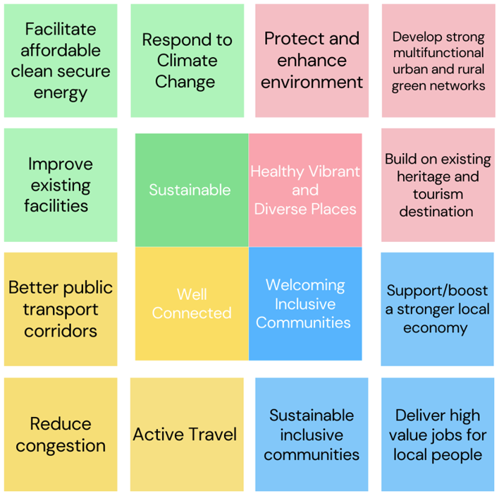
Themes and Objectives
Healthy, vibrant and diverse places
- Protect, maintain and enhance the distinct character, heritage identity and setting of Colchester city.
- Protect stretches of undeveloped countryside, enhance the quality of natural environment creating net gains to biodiversity, contributing to local nature recovery priorities and the creation of better connected green networks and waterways.
- Contribute to national commitments to halt and reverse biodiversity loss, including the UK’s ambition to protect at least 30% of land for nature by 2030.
- Encourage the redevelopment of brownfield land.
- Support Colchester’s tourism role through the provision of additional high-quality facilities.
- Create healthier food environments by managing the location and concentration of unhealthy food outlets to tackle obesity and diet-related inequalities and support access to local food growing.
- Protect and enhance the environment to prioritise the prevention of ill-health and support mental and physical wellbeing.
Sustainable
- Improve existing facilities and deliver sustainable and resilient infrastructure, including a multifunctional green network and waterways, utilities, roads and schools.
- Access to high quality healthcare that is deliverable and where needed.
- Facilitate affordable clean secure energy through the delivery of sustainable energy to achieve radical reductions in greenhouse gas emissions.
- Ensure development helps Colchester to adapt and increase its resilience to the effects of climate change.
- Support the reduction of waste in line with the waste management hierarchy.
Welcoming inclusive communities
- Deliver high value jobs for local people and support a stronger local economy.
- Focus on art culture, heritage and tourism.
- Deliver high quality public realm and enhance infrastructure to attract inward investment.
- Varied mix of housing to meet the needs of all, including social and lower income households.
- Safe, inclusive and sustainable.
- Access to key services and facilities for all.
Well-connected
- Better public transport corridors to reduce congestion and air pollution and increase active travel making cycling and walking more attractive.
- Create communities which reduce the need to travel, particularly by car for most of their daily needs.
Strategic Priorities for the Development and Use of Land
2.24In accordance with section 19(1B) of the Planning and Compulsory Purchase Act 2004, the following are the strategic priorities for the development and use of land in Colchester. These priorities are informed by the Vision, Themes and Objectives and are delivered through the Strategic Policies and other policies contained within this Local Plan.
- Delivering sufficient homes to meet Colchester's housing needs, including affordable, specialist and accessible housing.
- Supporting sustainable economic growth and providing sufficient employment land and opportunities.
- Directing growth to the most sustainable locations through the spatial strategy and settlement hierarchy.
- Delivering infrastructure, services and facilities alongside development.
- Addressing climate change mitigation and adaptation.
- Conserving and enhancing biodiversity, the green network and waterways and supporting nature recovery.
- Protecting and enhancing landscape character, the coast and the historic environment.
- Promoting healthy, inclusive and safe communities and reducing health inequalities.
- Delivering high quality design and place-making that creates sustainable, resilient and attractive neighbourhoods.
- Supporting sustainable transport, active travel and better connectivity.
- Managing water resources, flood risk and environmental quality.
3. Strategic Policies
3.1In accordance with national policy, this plan includes Strategic Policies which set out an overall strategy for the pattern, scale and design quality of places and make sufficient provision for:
- homes (including affordable housing), employment, retail, leisure and other commercial development;
- infrastructure for transport, telecommunications, security, waste management, water supply, wastewater, flood risk and coastal change management, and the provision of minerals and energy (including heat);
- community facilities (such as health, education and cultural infrastructure); and
- conservation and enhancement of the natural, built and historic environment, including landscapes and green infrastructure, and planning measures to address climate change mitigation and adaptation.
3.2Strategic Policies provide an overview that applies across the whole area, responding to the requirements of national policy and supported by more detailed topic development management and Place specific policies. In addition, neighbourhood plans must be in general conformity with the strategic policies contained in any development plan that covers their area. For the purposes of neighbourhood planning these are the strategic policies which will apply as required by national policy. Relevant Place policies will also apply to any neighbourhood plan prepared.
3.3The Strategic Policies (Policies ST1–ST9) set out the overarching principles and priorities for development across Colchester and establish the strategic direction of the Local Plan. Detailed development management policies (including those relating to environment, green network and waterways, homes, economy, place and connectivity) provide the criteria against which development proposals will be assessed. Where policies address similar matters:
- Strategic Policies establish the principle and objective;
- Development management policies provide the detailed requirements and assessment criteria; and
- Place Policies set out site‑specific requirements.
3.4In the event of any overlap, the more strategic policy shall take precedence.
Strategic Policies should not be interpreted as creating additional submission requirements where these are already addressed through development management and/or Place policies.
Policy ST1: Health and Wellbeing Comment
The way places are planned, designed and built can have a significant influence over health and wellbeing.
All development should be designed to provide opportunities for healthy lifestyles and contribute to the creation of healthier and inclusive communities and help to reduce health inequalities for people of all ages and abilities through placemaking.
The Council will continue to work with partners and health providers to improve and promote healthier and active lifestyles for our residents and communities.
Health and wellbeing outcomes are embedded throughout the policies in the Plan. To achieve healthy and inclusive communities, all new development should:
- Promote healthy neighbourhood design, providing opportunities for healthy lifestyles for all by creating well-designed, safe and accessible places.
- Provide healthy and affordable homes that meet the needs of the community.
- Provide easy access to natural environments including green and blue infrastructure and open spaces.
- Promote active and sustainable environments and encourage active travel.
- Promote a healthy food environment.
- Provide opportunities for all to access health facilities and services, a range of employment opportunities, and community, sport and recreation facilities. Where appropriate new development will be expected to deliver and/or contribute to the provision of new or improved facilities.
- Seek environmental improvements, minimising exposure to potential sources of environmental harm including pollutants and noise and improving air quality.
- Minimise, manage and mitigate against the effects of climate change.
In addition, and where appropriate, new development should support the provision of healthcare infrastructure to accommodate needs, in accessible locations, in line with the requirements outlined in the Infrastructure Delivery Plan and set out in Place policies.
A Health Impact Assessment (HIA) will be required for all residential development of 50 dwellings or more, non-residential development of 1,000sqm or more, all development in C2 use class (residential institutions) and hot food takeaways and fast food outlets in accordance with Policy PC1, in order to demonstrate that the development would have an acceptable impact on health and wellbeing. The scope and detail of the HIA should be proportionate to the size of development and should be agreed prior to commencement of the assessment with development management and public health officers. The Council will require Health Impact Assessments to be prepared having regard to the most up to date advice and best practice for such assessments, responding to the latest local public health data and insight from the community. The purpose of the Health Impact Assessment will be to identify the potential health consequences of a proposal and should be undertaken at an early stage of the development process, with evidence that the assessment has informed the design of the proposal
The assessment should include recommendations on how positive health benefits can be maximised and how negative impacts on health and inequalities can be avoided or mitigated. Where a development has a significant adverse impact on health and wellbeing, the Council will require applicants to provide for the mitigation of such impacts. Developments which will have an unacceptable significant adverse impact on health and wellbeing which cannot be mitigated, or that fail to offer reasonable provisions, will not be permitted.
Justification
3.5The purpose of this strategic policy is to ensure that all proposals support the health and wellbeing of all our communities. In line with national policy, Policy ST1 aims to achieve healthy, inclusive and safe places, enabling and supporting healthy lives and reducing health inequalities.
3.6Health and wellbeing objectives are established at a strategic level in the Vision and Strategic Policy ST1. Subsequent placemaking, design and place policies are intended to support delivery of these objectives and should not be read as introducing additional or standalone requirements unless explicitly stated.
3.7The policy acknowledges the interconnection between health and wellbeing and the climate, the environment, and place-making and design. Healthy lifestyles can be supported and improved through high quality inclusive design and planning, providing healthy homes, increasing inclusivity and providing access to local services; encouraging access to natural environments and encouraging active travel to enable communities to be physically active; and promoting access to healthy food. These principles, along with further information and guidance on their implementation can be found in the Essex Design Guide.
Policy ST2: Environment and the Green Network and Waterways Comment
All proposals must conserve and enhance Colchester’s natural and historic environment, including the protection and enhancement of sites of international, national, regional, and local importance. Development should protect and respond positively to the landscape character of Colchester informed by its biodiversity, geology, green network and waterways, history, archaeology and settlement identity, including sense of separation. The Council will support the use of Natural England’s Environmental Benefits from Nature tool.
Proposals must have regard to the strategic aims and objectives of the Essex Local Nature Recovery Strategy, including habitat creation in strategic opportunity areas and enhancement of ecological connectivity, and the Essex Coast Recreational disturbance Avoidance and Mitigation Strategy (RAMS) or any relevant successor documents.
Strategic areas with enhanced potential for habitat creation and ecological connectivity are shown on the policies maps as ‘strategic biodiversity areas’. These strategic biodiversity areas will be safeguarded from inappropriate development having regard to the policy context of the local plan and opportunities to strengthen and enhance habitat connectivity will be supported.
Detailed requirements relating to biodiversity net gain, ecological assessment and mitigation, green network provision, open space standards, and long-term management and maintenance are set out in Policies EN2, EN3 and GN1, and relevant Place policies.
Justification
3.9The purpose of this strategic policy is to ensure that all proposals conserve and enhance the natural and historic environment and that major residential proposals deliver contextually responsive, high quality open spaces. The key purpose of this strategic policy and all policies in the Environment chapter, is to respond to the creating a better environment agenda by halting overall biodiversity loss, supporting healthy well-functioning ecosystems, and supporting and establishing coherent ecological networks, with more and better places for nature for the benefit of wildlife and people. Detailed requirements for biodiversity net gain, ecological assessment, mitigation and protection of biodiversity are set out in Policies EN2 and EN3.
3.10The Local Plan evidence base includes evidence that is relevant to this strategic policy and the Environment and Green Network policies that follow, such as the Habitats Regulations Assessment, Biodiversity Protection and BNG Study, Strategic Biodiversity Assessment, Landscape Character Assessment, Local Wildlife Site Review and Colchester’s Green Network and Waterways Guiding Principles.
3.11 Planning reforms, the Environment Act, and the Environmental Improvement Plan, provide significant opportunities for planning to play a key role in creating a better environment for future generations. Responding to the increasing environmental agenda in plan making requires a coherent and streamlined approach which complements the complex environmental agenda requiring integrated, coordinated approaches to achieve multifunctional benefits from the use of land.
3.12Nature in Essex has suffered significantly over the last century, and continues to suffer, from species loss, habitat loss and increased habitat erosion and fragmentation. There are multiple causes to this loss and increased isolation of habitats across the landscape, including land use change, invasive species, pollution, overexploitation and climate change. It is crucial that nature recovery is at the centre of future action for the environment, to create new habitats and recover and enhance space for nature that has been lost or degraded.
3.13The Council was a Supporting Authority in the development of the Essex Local Nature Recovery Strategy (LNRS). The role of LNRS’ is to provide a county-wide, practical solution to driving action for nature recovery on the ground. The primary purpose of the Essex LNRS is to identify locations to create or improve habitat most likely to provide the greatest benefit for nature and the wider environment. The Council has had regard to the Essex LNRS throughout plan preparation.
3.14The presence of clusters of designated sites and, in some cases, older landscapes that aren’t designated but that have the potential to make a significant contribution to biodiversity, has been used to identify areas of significance for the conservation of biodiversity. These strategic biodiversity areas present the best opportunities for habitat creation and enhancement aimed at improving biodiversity. Each of the strategic biodiversity areas has an inherent degree of coherence and connectivity. Strategic biodiversity areas are shown on the policies map and are shown for context in the map below.
3.15Enhancing ecological connections as a priority is aimed at improving the robustness of species populations by increasing gene flow between nearby populations, allowing colonisation of new sites, and facilitating re-colonisation of sites where populations may be lost by adverse impacts. With climate change impacting on environmental conditions in a profound way, these connections also offer a chance for species to find somewhere better suited to their needs if necessary.
3.16Such connections also serve to improve the general ecological condition of the wider landscape, serving as a reservoir of biodiversity that can then permeate the whole landscape, including those areas of residential development to which they are connected.
3.17Development within strategic opportunity areas must ensure that it is appropriate and considers opportunities for habitat creation and enhancement aimed at improving biodiversity. Protecting, strengthening and enhancing habitats and corridors within the strategic biodiversity areas can be achieved through broadening connections and improving the condition of the habitats, as well as creating more links with nearby LoWS through the design of green infrastructure and mitigation habitats within development sites as well as through compensation measures and biodiversity net gain in the wider landscape.
Strategic biodiversity areas
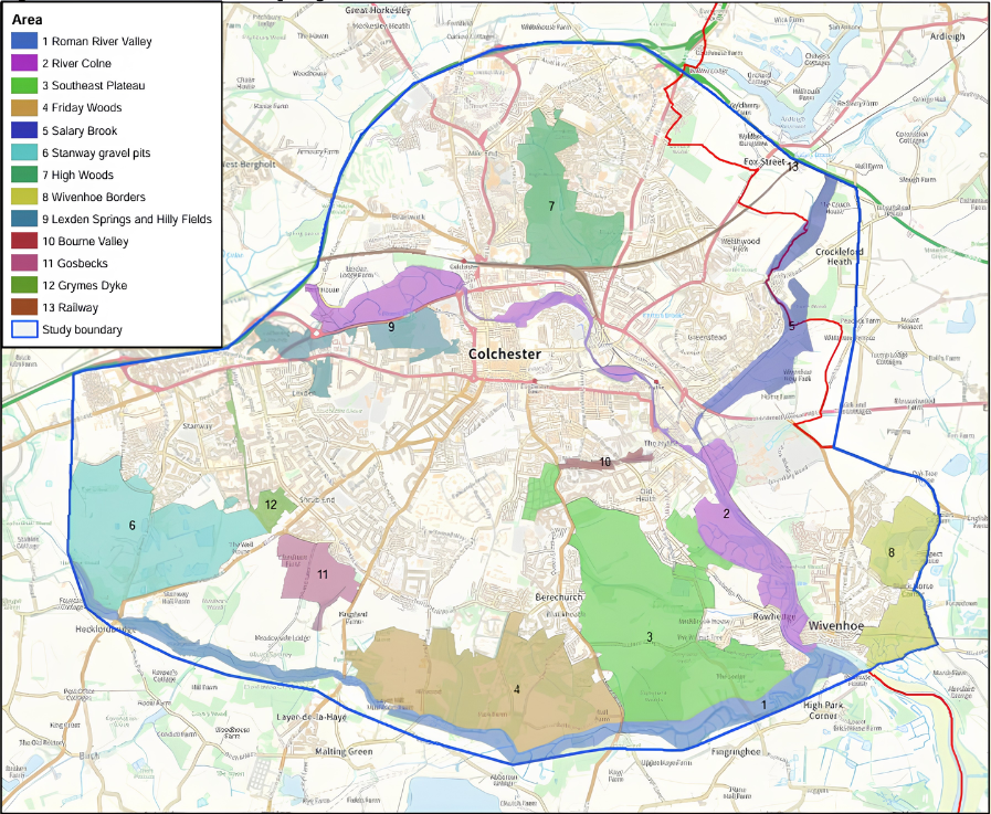
3.18The Colchester Orbital is an established and evolving strategic recreational and active travel route which forms a key component of the City’s green network. It provides opportunities to enhance connectivity between urban areas and the countryside, supporting active travel, health and wellbeing, and ecological connectivity. Development should, where appropriate, contribute to the delivery and enhancement of the Orbital through improved links, access points and improved supporting infrastructure and associated green infrastructure.
Policy ST3: Spatial Strategy Comment
Development will be directed to the most sustainable locations in Colchester district in accordance with the spatial strategy and settlement hierarchy to deliver the scale of growth identified in Policies ST5 and ST6. Growth will be infrastructure-led, ensuring that development is aligned with the timely provision of infrastructure necessary to support sustainable communities.
Proposals for development will be supported where they are located in accordance with the following sequential approach:
- Colchester Urban Area (including City Centre) as the principal focus of growth through redevelopment of previously developed land, high density development and regeneration.
- Growth and Opportunity Areas to deliver strategic scale growth, regeneration and supporting infrastructure in accordance with Place Policies and any adopted masterplans and DPDs.
- Large Settlements where development will be supported at a scale proportionate to their role, services and environmental constraints.
- Medium Settlements where development will be supported at a scale proportionate to the size and function of the settlement and its connectivity and supports local services and responds positively to infrastructure constraints.
- Small Settlements where small scale and infill development will be supported where it is proportionate and appropriate to the settlement, and respects local character and constraints.
- Areas outside of defined settlements or growth areas are classed as countryside and development will be restricted to uses appropriate to a rural location.
Development in locations well related to key transport corridors, particularly with access to the rail network, will be supported where it maximises sustainable travel opportunities and there is, or can be, sufficient capacity on the network and/or appropriate mitigation to support any enhancement required.
The re-use of previously developed land and higher density development (particularly in the Urban Area of Colchester) will be supported where it accords with design, character and infrastructure capacity considerations.
Proposals will be assessed in accordance with the settlement hierarchy below and relevant Place and development management policies. Proposals will be supported where they are consistent with the nature, role and function of the settlement having regard to cumulative impacts and the scale of growth over the plan period.
Settlement Hierarchy
|
Colchester Urban Area including City Centre |
|
Growth and Opportunity Areas Hythe Opportunity Areas Magdalen Street Opportunity Area Marks Tey Growth Area Tendring Colchester Borders Garden Community Growth Area University of Essex and Knowledge Gateway |
|
Large Settlements Tiptree West Mersea Wivenhoe |
|
Medium Settlements Abberton and Langenhoe Boxted Chappel and Wakes Colne Copford Dedham and Dedham Heath Eight Ash Green Fordham Great Horkesley Great Tey Langham Layer de la Haye Rowhedge West Bergholt |
|
Small Settlements Aldham Birch and Layer Breton Copford Green Easthorpe East Mersea Fingringhoe Great Wigborough Little Horkesley Messing Mount Bures Peldon Salcott Wormingford |
|
Countryside |
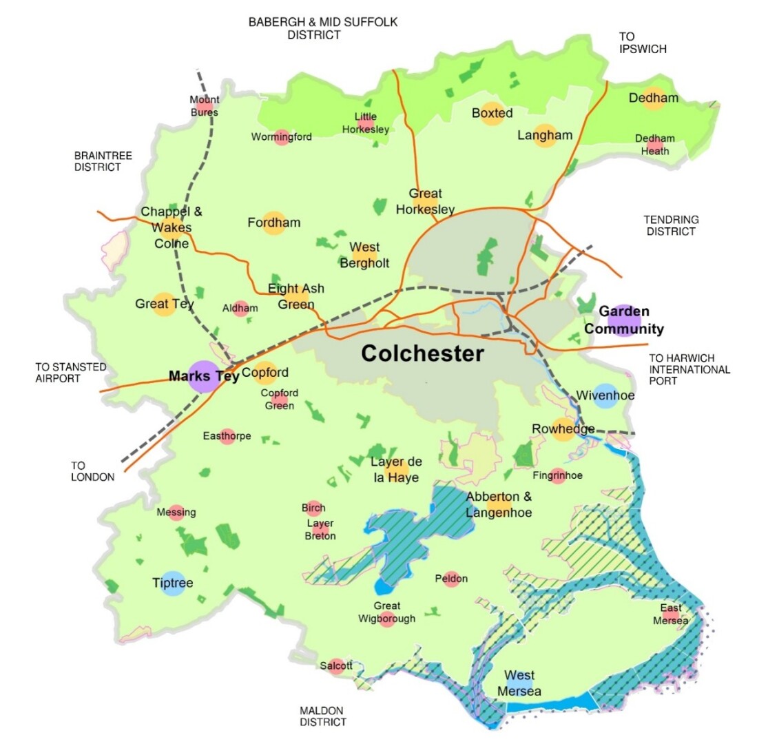
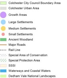
KEY DIAGRAM
Justification
3.19The spatial strategy establishes the overall distribution of development across Colchester district to 2043. The strategy provides the framework for the delivery of Colchester’s identified housing, employment and infrastructure needs over the plan period, taking into account the unique characteristics of areas across the City consistent with the presumption in favour of sustainable development in national policy. The settlement hierarchy forms part of the spatial strategy. The spatial strategy and settlement hierarchy recognise the relationship between the urban area of Colchester, growth and opportunity areas within and outside of the urban area [Marks Tey and Tendring Colchester Borders Garden Community (TCBGC)], and the larger settlements of Tiptree, West Mersea and Wivenhoe. It also recognises the role that medium and small settlements play in creating diverse places across Colchester district, as well as the importance of the countryside that should be protected. The spatial strategy and settlement hierarchy are informed by the evidence base, including assessments of accessibility, environmental constraints, infrastructure capacity and the sustainability of settlements. The key diagram illustrates the spatial strategy.
3.20In the first instance, development is directed to Colchester Urban Area, including the City Centre. This reflects its role as the main centre for jobs, services, culture and transport. Prioritising development in the urban area supports the efficient use of land, including re-use of previously developed land and higher density development, in line with national policy.
3.21The next tier in the settlement hierarchy is growth and opportunity areas. A number of sites are allocated for residential, employment / mixed use development within the urban area of the City. The Hythe which has seen significant changes over the years, notably through recently approved and built student accommodation, is identified as an opportunity area where there are opportunities for wider regeneration. This area is an established regeneration area that seeks to deliver sustainable, mixed-use neighbourhoods, identifying the River Colne as a feature and respecting the historic character of the area. Magdalen Street, where regeneration could help deliver a new and improved gateway to the City Centre, is also identified as an opportunity area. There are a number of older commercial buildings suitable for reuse and or redevelopment to enhance this area. This tier in the hierarchy also includes the University of Essex and Knowledge Gateway.
3.22Marks Tey is identified in this tier as a growth area, recognising potential opportunities for strategic scale growth and potential for improvements to infrastructure and placemaking. Its strategic location along with the benefits the railway station brings, support the potential for expansion. However, there is also recognition that infrastructure improvements will be required in order to support development at the scale promoted. It is recognised that growth at Marks Tey will benefit from a masterplanned approach considering the opportunities and constraints holistically. TCBGC is established and defined in a separate adopted Development Plan Document (DPD). It continues to form an integral part of how this area of North Essex will develop up to 2043 and beyond. In recognition of the contribution it will make to towards the supply in this plan period for Colchester it is defined as a growth area in the hierarchy.
3.23 The strategy recognises the role of larger settlements (Tiptree, West Mersea and Wivenhoe). These larger settlements have the most facilities, services and opportunities. These settlements also have some of the largest populations of Colchester. Growth in these settlements not only reflects their size but also considers the opportunities and constraints that apply to each location.
3.24The spatial strategy supports development along key transport corridors recognising their function and connectivity and potential to support growth and modal shift. Transport corridors typically comprise strategic roads, rail lines and high-frequency public transport routes that provide high levels of accessibility to jobs, services and facilities.
3.25 Medium and small settlements will accommodate growth appropriate to the size and location of the settlement and its constraints. Growth is not directed to all of the small settlements as appropriate land for growth was not identified for every small settlement.
3.26The spatial strategy recognises that some medium settlements are particularly well located in relation to key transport corridors and are therefore capable of accommodating a greater scale of growth than would be expected under a purely proportionate approach. In particular, Langham and Great Horkesley benefit from their proximity to the A12 corridor and Marks Tey also in respect of the railway network, providing strong connectivity to Colchester and the wider region. In line with the transport corridor approach set out in the spatial strategy, higher levels of growth in these locations support sustainable travel patterns, make efficient use of accessible locations and enable the delivery of infrastructure and community benefits, whilst remaining consistent with the overall strategy of directing development to the most sustainable locations.
3.27It is important to consider the cumulative impacts on local infrastructure, landscape character and biodiversity of multiple development proposals to ensure that the cumulative impacts of growth does not harm the nature, role and function of the settlement taking into account development proposed over the plan period.
3.28The spatial strategy recognises the importance of the countryside, which will be protected from inappropriate development. Environmental and infrastructure considerations are integral to the spatial strategy and Policies ST2, ST7 and ST7a and the policies in the Environment chapter are relevant.
3.29The effectiveness of the spatial strategy will be monitored through, for example, the delivery of housing and employment, the reuse of previously developed land and the provision of supporting infrastructure.
Policy ST4: Development in the Countryside Comment
Proposals in the countryside must demonstrate functional and locational justification for a countryside setting while supporting the vitality of rural communities. This will be balanced against ensuring development does not have an adverse impact on the different roles and relationships between settlements and their separate identities, valued landscapes, the intrinsic character and beauty of the countryside and visual amenity.
The intrinsic character and beauty of the countryside will be recognised and assessed, and development will only be permitted where it would not adversely affect the intrinsic character and beauty of the countryside.
Proposals must consider the role the landscape plays as an open buffer between settlements or areas of a settlement, and the resulting sense of separation and distinctive identity.
Within valued landscapes, development will only be permitted where it would not impact adversely and would protect and enhance the factors that contribute to valued landscapes.
Proposals for sustainable rural businesses will be supported if they are of an appropriate scale, meet a local employment need, minimise negative environmental impacts, and harmonise with the local character and surrounding countryside where they are being proposed.
Proposals for the delivery and operation of essential utilities infrastructure, where there is a proven need and a countryside location is essential for the delivery of those utilities, will be supported where they accord with other policies in the development plan.
Where residential proposals are located outside defined settlement boundaries or growth areas, there should be consideration of the physical and functional connection to the defined settlement in the first instance. The scale of development should be proportionate to the size and function of the settlement and avoid cumulative impacts on local infrastructure, landscape character, and biodiversity. Residential proposals in the countryside should conserve and enhance the character and quality of the landscape, and it must be proven that they will protect and reinforce the rural character of the areas where development is proposed. Proposals will need to demonstrate that the scheme respects the character and appearance of landscapes and the built environment and preserves or enhances the historic environment and biodiversity in line with policies in this Plan. Proposals should demonstrate how they contribute to sustainable development, including access to services, active travel and public transport options, where available.
Justification
3.30 The purpose of the planning system is to contribute to the achievement of sustainable development. National Policy recognises that there are three dimensions to sustainable development: economic, social and environmental. Settlement boundaries and defined growth areas are an essential tool for the management of development and contribute to the achievement of sustainable development by preventing the encroachment of development into the countryside, protecting rural character. The spatial strategy (Policy ST3)directs development to the most sustainable locations across Colchester.
3.31 Areas outside of settlement boundaries and growth areas are defined as ‘Countryside’. Within the countryside, there are a number of very small villages and hamlets and isolated clusters of dwellings which lack any community facilities or access to services or public transport and rely on nearby larger settlements to meet their daily needs. It is essential that development is restricted in the countryside to protect landscape character and quality.
3.32Development within the countryside will accordingly be limited to activities that either require a rural location or help sustain a rural community and local economy and which help protect the rural character of the areas where a development is being delivered.
3.33National Policy includes examples of exceptions whereby proposals for isolated dwellings in the countryside may be acceptable. The Council’s interpretation of ‘isolated’ are sites that are physically isolated relative to existing settlements, and sites that are functionally isolated relative to services and facilities.Provision for Homes and Jobs
3.34Paragraph 61 of the NPPF states that a key objective of the Government is to boost the supply of homes. It stresses the importance of providing a sufficient amount and variety of land which can come forward where it is needed. In accordance with Paragraph 62 of the NPPF the Council commissioned a Local Housing Needs Assessment which used the standard method as set out in national planning practice guidance (December 2024, updated August 2026), to consider the overall need for housing in Colchester. This identifies the need for different types of homes, and needs of different groups within the local community. The Council has engaged with Tendring District throughout the plan making process as it shares a housing market area.
3.35The Local Housing Needs Assessment update August 2026 confirms that using the Standard Methodology for calculating housing need, there is a need for1276 new homes per year. This equates to 21,692new homes over the plan period to 2043. In accordance with the NPPF December 2024, this is a mandatory target which must be planned for.
3.36 In the last financial year (April 2025 to March 2026) 924 new homes were delivered in Colchester. There are also a number of sites that have already been granted planning permission or are committed and supported by with evidence to support their early delivery. These are forecast to deliver 5,588 new homes in the plan period as outlined in Policy ST5.
3.37 The Tendring Colchester Borders Garden Community will deliver circa 7,500 new homes in the longer term. A total of 3,750 new homes will be delivered up to 2043, with the number of new homes to be divided equally between Tendring and Colchester. As a result, 1,875 new homes from the Garden Community will make a contribution to the housing needs of Colchester within the plan period.
3.38 Based on past delivery records, windfall sites will also make an important contribution to Colchester’s housing need. Windfall sites are defined as sites that are not allocated in the Local Plan. Assessing past contributions from windfall sites in Colchester, has demonstrated that an average of 238 homes per annum have been delivered on windfall sites (from 2016/17 to 2025/26). As a result, a windfall allowance of 220 new homes a year for the later 11 years of the plan period and a lower allowance in earlier years which reflects any known windfalls, is considered a robust and justified contribution to the overall housing supply. 2,985 homes are anticipated to be delivered through windfall sites by 2043.
3.39 Taking all the above into account, during the remainder of the plan period, the Council need to plan for a minimum of 11,400 new homes in order to meet the housing needs for Colchester.
3.40 Colchester has an excellent track record of housing delivery. Since 2001/02 it has overseen the delivery of over 23,000 new homes at an average rate of 928 new homes per year. Over the previous plan period to date (2017 – 2026) the Council exceeded its cumulative housing target by over 200 dwellings. Therefore, at the beginning of the new plan period the Council is not in a position where it needs to make up any previous shortfall in housing delivery.
3.41 The methodology for planning for employment growth is less rigid than that for housing, although the NPPF requires plans to identify a future supply of land which is suitable, available and achievable for economic development uses over the Local Plan period
3.42The Employment Land needs assessment has considered the approach, existing supply and demand to arrive at a need of 49.8 hectares of employment land up to 2041. This is based on the preferred scenario (Labour Supply) which is based on population projections, linked to housing growth projections, it represents an approach which seeks to maximise the opportunities for the economically active population in the Local Authority Area. This represents the most optimistic scenario for employment growth to align with wider corporate objectives for economic growth.
3.43The Employment Study identifies key sectors likely to influence demand for employment space over the plan period including the digital, creative and tech and financial and business service sectors, and key sectors likely to influence demand for industrial space include advanced manufacturing, construction, transport and logistics and green energy. Proposals which support these sectors will particularly be encouraged in line with the requirements of the Policy and are set out in the relevant Place Policy.
Policy ST5: Colchester’s Housing Need Comment
The Council will plan, monitor and manage the delivery of at least 21,692 new homes in Colchester City between 2026 and 2043.
The annual housing requirement for Colchester is 1,276, as identified by the Standard Methodology.
Table ST5.1: Housing Supply
|
Housing Supply as at 31 March 2026 |
Net New Homes |
|
Existing Commitments (sites with planning permission) |
5,488 |
|
Tendring Colchester Borders Garden Community |
1,875 |
|
Windfall Allowance |
2,985 |
|
Local Plan Allocations |
12,208 |
|
TOTAL SUPPLY |
22,556 |
The Council will maintain a sufficient supply of deliverable and developable sites to provide for at least five years’ worth of housing on a rolling basis, plus an appropriate buffer in accordance with national policy.
The overall distribution of new housing across Colchester is guided by Spatial Strategy (Policy ST3).
TABLE ST5.2 Local Plan Housing Allocations
|
Location |
Number of New Homes |
Policy Reference |
|
Brittania Car Park |
100 |
PP1 |
|
Vineyard Gate |
100 |
PP2 |
|
Runwald St Car Park |
40 |
PP3 |
|
Braiswick |
30 |
PP4 |
|
Land at Chesterwell |
50 |
PP5 |
|
Land at Colchester Station |
250 |
PP6 |
|
Land off Bakers Lane |
120 |
PP7 |
|
Land off Lakelands Crescent |
5 |
PP8 |
|
Northeast Colchester |
2,000 |
PP9 |
|
Land South of Berechurch Hall Road |
875 |
PP10 |
|
Europit Site |
40 |
PP11 |
|
Gas Works and Hythe Scrap Yard Site |
200 |
PP14 |
|
Hawkins Road |
50 |
PP15 |
|
King Edward Quay Opportunity Area |
200 |
OA1 |
|
Land East of Hawkins Road Opportunity Area |
150 |
OA2 |
|
Magdalen Street Opportunity Area |
85 |
OA3 |
|
Marks Tey Growth Area |
2500 |
OA5 |
|
Land North of Oak Road, Tiptree |
650 |
PP19 |
|
Land at Bonnie Blue Oak, Tiptree |
30 |
PP20 |
|
Highlands, Kelvedon Road, Tiptree |
10 |
PP21 |
|
Former Telephone Exchange, Station Road, Tiptree |
5 |
PP22 |
|
Land at New Park Cottage, Tiptree |
25 |
PP22b |
|
Land East of Dawes Lane, West Mersea |
300 |
PP23 |
|
Land Northwest of the Fire Station, Wivenhoe |
200 |
PP24 |
|
View Park, Abberton and Langenhoe |
50 |
PP25 |
|
Land North of Boxted Straight Road |
150 |
PP26 |
|
Swan Grove, Chappel |
35 |
PP27 |
|
Land West of Station Road, Wakes Colne |
200 |
PP28 |
|
Land East of School Road, Copford |
300 |
PP29a |
|
Land South of Copford Village Hall, Copford |
50 |
PP29b |
|
Queensbury Avenue, Copford |
70 |
PP29c |
|
Land South of Long Road, Dedham |
15 |
PP30 |
|
Land North of Halstead Road West of Fiddlers Wood, Eight Ash Green |
250 |
PP32 |
|
Land South of Halstead Road, Eight Ash Green |
250 |
PP32a |
|
Land East of Plummers, Fordham |
25 |
PP33 |
|
Land North of Coach Road, Great Horkesley |
800 |
PP34 |
|
The Old School, Great Horkesley |
13 |
PP35 |
|
Land at Earls Colne Road, Great Tey |
150 |
PP36 |
|
Land East of Brook Road Great Tey |
50 |
PP36a |
|
Land North of Park Lane, Langham |
850 |
PP37 |
|
Land opposite Wick Road, Langham |
10 |
PP38 |
|
Land at The Furze, Layer de la Haye |
10 |
PP39 |
|
Land West of The Folley, Layer de la Haye |
75 |
PP40 |
|
Maltings Green Lane Layer De La Haye |
30 |
PP40a |
|
Rowhedge Business Park, Rowhedge |
50 |
PP41 |
|
Land at White Hart Lane, West Bergholt |
185 |
PP42 |
|
Land North of Colchester Road, West Bergholt |
185 |
PP43 |
|
Land off New Road, Aldham |
15 |
PP45 |
|
Land at Birch Green, Birch |
15 |
PP46 |
|
Land at Picketts Farm, Fingringhoe |
5 |
PP47 |
|
Kelvedon Road, Messing |
25 |
PP48 |
|
Land South of Mersea Road, Peldon |
25 |
PP49a |
|
Land West of Maltings Road Peldon |
5 |
PP49b |
|
Cowdray Avenue (BT site), Colchester |
40 |
PP50 |
|
Former Land Rover site, Cowdray Avenue, Colchester |
25 |
PP51 |
|
Car park, Guildford Road (BT Repeater Station), Colchester |
25 |
PP52 |
|
Land at Chapmans Farm, Colchester |
35 |
PP53 |
|
Land at Sheepen Place, Colchester |
100 |
PP54 |
|
Land adjacent Lethe Grove, Colchester |
75 |
PP55 |
|
TOTAL |
12,208 |
Justification
3.44To plan for Colchester’s housing need, the Council needs to ensure enough land is allocated for residential uses to accommodate the predicted level of housing growth over the plan period. The land required to accommodate this housing growth is known as the housing land supply. The NPPF requires policies to identify sufficient sites to deliver the required housing supply over the plan period. The housing land supply comprises existing commitments and new allocations.
3.45The standard method for assessing local housing need produces a figure that is subject to change as its inputs are updated periodically by Government and the Office for National Statistics. Throughout the plan preparation process, the resulting local housing need figure for Colchester has fluctuated between 1,276 and 1300 dwellings per annum. To ensure a robust and consistent housing requirement throughout the plan period, the Council has identified a small surplus, providing a prudent allowance for future variations in the standard method whilst supporting the Plan's objective of maintaining an adequate supply of homes.
3.46Through the previous Local Plan, the principle of development of a Garden Community on the Tendring and Colchester border was established. Colchester City Council, Tendring District Council and Essex County Council have worked together to prepare a Development Plan Document which provides a framework to guide the development of the Garden Community. Circa 7,500 new homes will be delivered at the Garden Community upon completion, with delivery through the plan period contributing to Colchester’s supply by 1875.
3.47Existing commitments are residential sites with planning permission or where the granting of planning permission is considered to be imminent. Many of these sites, were allocated for residential use in the current Adopted Local Plan. Existing commitments also includes allocations from made Neighbourhood Plans
3.48Due to historic trends of windfall within the City, the Council will be applying a windfall allowance in line with paragraph 73(d) of the NPPF. The Council’s criteria for a site to be considered windfall is that it should not form part of a current allocation. There is no one approach to a windfall allowance methodology, but it is reasonable to consider past windfall rates as a basis for the expectation of the levels of windfall that will come forward in the future. This approach is widely used and can aid in considering the likely windfall that will come forward in the future.
3.49Allocations are sites which are proposed for residential uses as part of the preparation of this Local Plan. Colchester has a very good track record of regenerating previously developed land within its urban area and as a result the City has a limited and diminishing supply of brownfield sites that can contribute to accommodating new growth. Accordingly, allocations within this Submission Local Plan include a high level of new greenfield sites. These sites have been subject to thorough assessment to determine their sustainability and suitability for residential uses. The same assessment has been undertaken for allocations in the current Adopted Local Plan which have not yet been implemented. All allocations have also been subject to discussions with stakeholders to ensure sites have been selected based on their availability, achievability and deliverability. This is important to ensure the plan can seek to deliver policy compliant schemes.
The Place Policies in this Local Plan provide detail on specific new allocations along with further information on infrastructure improvements and mitigation measures required to address site constraints and opportunities at each location. Allocations will provide approximately 12,208 new homes. All allocations are set out in their respective Place Policies.
3.50Ensuring the quality of new housing development is of equal importance to ensuring its quantity. The Council will actively work with landowners, planning agents and housebuilders to bring forward those allocated sites that accord with the overall spatial strategy and relevant policies in the Plan.
Policy ST6: Colchester’s Employment Needs Comment
The Council will plan, monitor and manage the delivery of at least 49.8ha of employment land in Colchester City to meet the projected demand up to 2043. Employment uses will be provided on a range of sites including allocations, sites with planning permission and through intensification or redevelopment within existing employment areas, including but not limited to, the sites identified in Table ST6.1 below to ensure jobs are accessible to new and existing communities across Colchester.
Table ST6.1: Local Plan Employment Provision
|
Location |
Employment Land (approx. ha) |
Policy Reference |
|
Land north of Axial Way, Northern Gateway, North Colchester |
3.4ha |
OA4 |
|
Colchester Business Park |
2.4ha |
PEP1 |
|
Knowledge Gateway |
4.5ha |
PEP2 |
|
Coal Yard Site |
0.9ha |
PEP13 |
|
Maldon Road |
0.7ha |
PEP4 |
|
Marks Tey |
18ha |
OA5 |
|
Anderson’s Site, Marks Tey |
3.2ha |
PEP6 |
|
Highlands Nursery, Tiptree |
1.1ha |
PEP7 |
|
Land South of Factory Hill, Tiptree |
4.7ha |
PEP8 |
|
Land at Tower Business Park, Tiptree |
0.5ha |
PEP16 |
|
Bullbanks Farm, Eight Ash Green |
0.8ha |
PEP9 |
|
Lodge Lane, Langham |
1ha |
PEP10 |
|
Land at Pattens Yard, West Bergholt |
2ha |
PEP11 |
|
Land at Wakes Hall Business Centre |
0.9ha |
PEP12 |
|
Land at Former Mill Race Nursery, Aldham |
1.1ha |
PEP15 |
|
Tendring Colchester Borders Garden Community |
4.6ha |
ST9 |
|
TOTAL |
49.8ha |
Proposals for new employment uses within existing and defined employment areas will be supported. Employment uses for the purposes of this policy are defined as Use Classes E(g), B2, and B8. Alternative economic class uses may contribute to the provision of jobs providing flexibility and securing delivery of additional jobs. Suitable alternative economic uses will be supported within existing and defined areas where they are in accordance with all relevant policies in the plan, including impact assessments where these alternative uses are for town centre uses and the threshold applies.
Lorry parking facilities and associated overnight layover facilities in appropriate locations within close proximity to the strategic road network will be supported where they are in accordance with relevant national and local guidance and all relevant policies in this Plan.
Justification
3.51National Policy requires that planning decisions should help create the conditions in which businesses can invest, expand and adapt. They should support economic growth and productivity, taking into account both local business needs and wider opportunities for development. Decisions should also allow an area to build on its strengths, counter any weaknesses, and address any challenges in the future. Planning policies should set out a clear economic vision and strategy which positively and proactively encourages sustainable economic growth. National Policy states that Councils should identify a future supply of land which is suitable, available and achievable for economic development uses over the Local Plan period.
3.52To plan for To plan for Colchester’s employment needs, the Council needs to ensure that enough land is allocated, and sufficient policy approaches adopted to deliver sustainable economic growth across Colchester. The Colchester Employment Land Needs Assessment provides an assessment of the balance of supply and demand in the context of changing employment needs, trends and challenges. The Employment Study demand assessment estimates that there is a net additional demand for 49.8ha of employment land across Colchester over the plan period.
3.53The purpose of the policy is to ensure that land is allocated and safeguarded for employment purposes that meet the needs of Use Classes E(g), B2 and B8 as defined by the Use Classes Order 1987 (as amended), in sustainable locations and in line with recommendations set out in the Colchester Employment Land Needs Assessment. The policy identifies land that, in addition to existing approved permissions within the planning pipeline, will meet the projected demand for additional good quality, well-located employment sites. Some of these sites are employment allocations that have been carried forward from the adopted Local Plan or allocations contained in adopted Neighbourhood Plans.
3.54pThe Place Employment Policies provide detail on specific new allocations along with further information on infrastructure improvements and mitigation measures required to address site constraints and opportunities at each location. An Employment and Skills Plan will be required in line with ECC guidance. This must be prepared collaboratively with the Council and relevant stakeholders.
3.55In addition to land allocated for employment uses as set out in Table ST6.1, employment uses will also be delivered through opportunity areas and mixed use and larger residential allocations as set out in the relevant Place Policy.
3.56 Existing fit for purpose employment sites are protected for employment uses through other policies in the plan including Policy E1.
3.57 Further detail on employment provision in the Colchester Tendring Borders Garden Community can be found in Policy ST9.
3.58The importance of providing appropriate lorry parking facilities and related driver amenities to support the strategic road network is recognised. The Council will work with partners to ensure that where required and appropriate, adequate lorry parking and associated facilities are provided.
Policy ST7: Infrastructure Delivery and Impact Mitigation Comment
All development must be supported by infrastructure, services and facilities that are identified as being needed to serve the needs arising from the development. Permission will only be granted if it can be demonstrated that there is sufficient and appropriate infrastructure capacity to support the development or that such capacity will be delivered by the proposal. It must further be demonstrated that all necessary infrastructure will be delivered at an appropriate time to meet the requirements of the development, and that such capacity will prove sustainable over time in physical and financial terms.
Where a development proposal requires additional infrastructure capacity to be deemed acceptable, mitigation measures must be agreed with the Council and the appropriate infrastructure provider. Such measures may include:
Financial contributions towards new or expanded facilities and the maintenance thereof;
- on-site provision of new facilities (which may include building works);
- off-site capacity improvement works; and/or
- the provision of land.
Developers will be expected to contribute towards the delivery of relevant infrastructure as required and supported by up-to-date evidence from appropriate sources including the Infrastructure Audit & Delivery Plan (IADP) and any subsequent updated evidence, along with information from local sources including parish and town councils. All development will be required to either make direct provision or to contribute towards the provision of local and strategic infrastructure required by the development which will include (but not be limited to) contributions to the following where relevant;
- Transport Infrastructure / Highways improvements
- Active Travel, Public Transport, Electric Vehicle infrastructure, Park&Ride/Choose
- Education Secondary, Primary, Early Years and Childcare,
- Sport and Leisure, Open Spaces,
- Community Facilities
- Healthcare
- Police, Fire and Rescue and Ambulance Services)
- Green Infrastructure /SANG
- Utilities
In addition, there are a number of strategic infrastructure requirements that all new development will be expected to contribute to;
- Upgrades to the strategic road network
- Traffic management measures which improve the Colchester wide traffic flow across the local and strategic network including dynamic traffic management. Specific projects to mitigate wider impacts include;
- Dynamic traffic management across the network
- Maldon Road/Warren Lane junction
- Improvements at A12/A120 Junction 29
- Greenstead roundabout and Wivenhoe Park corner junction co-ordinated with rapid transit system priority crossings
- Improvements / alterations A12/A120(W) Junction 25 including Marks Tey Roundabout and Prince of Wales Roundabout
- Improvements at A12 Junction 26
- A12 Junction 27 signalisation
- Improvements to A133 including Clingoe Hill Greenstead Roundabout, Lower Harwich /Ipswich Roads
- Aldham and Eight Ash Green Halstead Road Junction Improvements
- Improvements to Colchester hospital
- Enlarged swimming pool provision
- New emergency services hub
This policy will apply to all development proposals. Location specific infrastructure requirements are also contained within the relevant site allocation policies. Where the mitigation requires onsite delivery the Place Policies identify site specific requirements which includes the provision of sufficient land where appropriate.
At the time of adoption, every allocation will be considered to be viable, based on information provided to the Council. Where an applicant/developer is seeking an exception to this policy later in the plan period, it will only be considered when all of the following criterion are met:
- A fully transparent open book viability assessment has proven that full mitigation cannot be afforded, allowing only for the minimum level of developer profit and landowner receipt necessary for the development to proceed; and
- It is proven that the public benefit of the development proceeding without full mitigation outweighs the collective harm; and
- Full and thorough investigation has been undertaken to find innovative solutions to issues and all possible steps have been taken to minimise the residual level of unmitigated impacts; and
- Obligations are entered into by the developer that provide for appropriate mitigation in the event that viability improves prior to completion of the development. In such cases the Council may seek a staged review of the viability of a scheme with the aim of achieving policy compliance over time. This may include securing a review mechanism by legal agreement specifying trigger points for undertaking a review such as later phases of a scheme or reserved matters applications.
The Council is intending to introduce a Community Infrastructure Levy (CIL) and will implement such for areas and/or development types where a viable charging schedule would best mitigate the impacts of growth. Section 106 will operate alongside CIL and will remain the appropriate mechanism for securing land and works, affordable housing and financial contributions where a sum for the necessary infrastructure is not secured via CIL.
Provision for education use that forms part of extant planning permissions will be safeguarded.
New streets should seek to be built to adoptable design standards in adherence with current guidance and standards. Where streets are not built to an adoptable standard, there must be a substantive place making benefit.
Justification
3.59 The sustainable delivery of new homes and jobs needs to be supported by the provision of appropriate new and upgraded infrastructure, including transport, community facilities and utilities. New development can place additional demand on existing infrastructure. Therefore, new development proposals must contribute to improvements in infrastructure to cater for the additional needs that they generate.
3.60The NPPF requires that all plans should promote a sustainable pattern of development that seeks to ‘align growth and infrastructure’. The NPPF requires that strategic policies should set out an overall strategy for the pattern, scale and design of places and make sufficient provision for infrastructure for transport, telecommunications, security, waste management, water supply, wastewater, flood risk and coastal change management, and the provision of minerals and energy (including heat); community facilities (such as health, police, fire and rescue and ambulance, education and cultural infrastructure); and green infrastructure. It also requires that plans should set out the contributions expected from development, including infrastructure.
3.61The purpose of the policy is to ensure that provision of infrastructure is aligned with growth. The policy identifies items of strategic infrastructure necessary to serve new development during the Plan period. All developments may be required to contribute to the provision of these projects. Site allocation policies in the plan will identify essential site-specific infrastructure relevant to the allocation.
3.62An Infrastructure Audit and Delivery Plan (IADP) supports the Local Plan. This has been developed with infrastructure service providers and partner organisations to determine where additional infrastructure is necessary. The IADP will sit alongside the Plan and provide specific detail on the main items of infrastructure required, when they are likely to be required, and who will provide them. The IADP will be supplemented by updated evidence over the lifetime of the plan which will inform the infrastructure to be provided in relation to individual developments.
3.63 The broad categories of necessary infrastructure included in the IADP include:
- Social Infrastructure (Education, Early Years and Childcare, Sport and Leisure, Open Spaces, Green Infrastructure, Community Facilities, Primary Healthcare, Health Services and Police, Fire and Rescue and Ambulance Services)
- Transport Infrastructure (Active Travel, Public Transport, Roads, Electric Vehicle infrastructure)
- Utilities, Waste and Water (Utilities, Telecommunications, Water, Wastewater, Flood Defence, Surface Water Management, Water Resource Management)
3.64The Council will seek contributions from developers to fund new facilities and improvements to existing infrastructure and the environment where it is necessary to mitigate the impact of new development. Local communities should be involved in the setting of policies for contributions expected from new development and policies in the Place section of this Plan reflect that. Site‑specific infrastructure requirements are identified in relevant Place Policies.
3.65The Local Plan has been informed by evidence of infrastructure and affordable housing need, and a proportionate assessment of viability that considers all relevant policies, and local and national standards. Accordingly, allocations will be made based on evidence that they are viable.
3.66Planning obligations will be secured through section 106 agreements, unilateral undertakings and section 278 agreements. Contributions may also be made through the Community Infrastructure Levy (once adopted), which applies a standard charge to developers to fund supporting infrastructure such as transport, schools, community facilities and health facilities,
3.67The Council continues to work with relevant government departments, infrastructure providers, developers and other partners to determine and facilitate the delivery of the wide range of infrastructure required to support development.
3.68Further details on the Councils approach to infrastructure delivery, developer contributions and the charges that will apply are contained within Guidance Notes on the Councils website.
3.69Provision for education needs including as part of extant planning permissions is secured. This includes land at Chesterwell, in North Colchester; London Road, Stanway; and Barbrook Lane, in Tiptree. All such land should meet criteria set out in the relevant guidance and facilitate delivery in line with Essex School Design Guidance.
Policy ST7a: Sustainable Transport and Connectivity Comment
To achieve the vision to create well connected communities and increase sustainable and active travel, development will be required to focus on delivering connectivity and providing better access to sustainable transport to provide a genuine choice of travel options.
New development must be planned and designed to promote the use of sustainable travel, through a vision led approach, creating places that maximise opportunities for sustainable travel for all and support healthy and active lifestyles.
Proposals for development should support the provision of infrastructure to encourage sustainable and active modes of travel in line with other policies in this Plan. Development should seek to connect to and enhance strategic active travel routes, including the Colchester Orbital, where these are relevant to the site and its context.
Developers will be required to submit a Transport Statement or Transport Assessment, in line with thresholds set out in the latest guidance to assess the potential transport impacts of the development. The Transport Statement or Assessment must demonstrate how the development will encourage active and sustainable transport, demonstrating how opportunities for active and sustainable measures have been maximised and how a modal shift to active and sustainable modes of travel will be achieved, and mitigate traffic impacts in terms of capacity and safety, to the satisfaction of the Highway Authority.
Development proposals will be required to produce a Travel Plan in line with thresholds and guidelines set out in the latest published guidance. Any Travel Plan should include an Action Plan setting out specific actions, timelines and targets to be monitored and reviewed.
All development proposals should demonstrate safe and suitable access to required highway design standards. The point of vehicle access should be agreed with the Highway Authority and demonstrate that the proposal would not be detrimental to highway capacity or safety.
Justification
3.70Active and sustainable travel are key elements of sustainable development. The Local Plan’s strategy for growth is to start with the most sustainable and accessible locations in the urban area or close to transport corridors and existing centres, where there tends to be a range of employment opportunities, facilities, services and travel choices for future communities.
3.71National policy requires transport issues to be considered from the earliest stages of plan making and development proposals using a vision-led approach to identify transport solutions. It requires the planning system to focus significant development on locations which are or can be made sustainable, through limiting the need to travel and offering a genuine choice of transport modes. This can help to reduce congestion and emissions and improve air quality and public health.
3.72The purpose of this policy is to maximise opportunities for active and sustainable travel within all new development and ensure that development proposals support active and sustainable travel opportunities. The policy is supported by the Local Plan evidence base which has identified a vision-based approach to transport mitigation measures required to mitigate the impacts of planned growth across the Local Plan area and plan period.
3.73The Essex Local Transport Plan (LTP) sets out Essex County Council’s transport vision and priorities for Essex. Development proposals should align with the proposed Essex LTP4, prioritising active and sustainable travel and demand management measures to reduce car dependency.
3.74Travel Plans are essential to inform residents and employees of the travel choices available and to encourage them to make use of sustainable and active travel infrastructure. Travel Plans should set measures to promote and encourage sustainable travel, including active modes, and be integrated into the design and occupation of a new development rather than retrofitted after occupation. Travel Plans should incorporate ambitious but achievable mode share targets and contain details of the monitoring process and what further measures will be required if the targets are not met.
3.75The Essex County Council Developers Guide to Infrastructure Contributions, or any subsequent updated guidance, should be used for guidance on Transport Assessments, Transport Statements and Travel Plans.
Policy ST8: Place Shaping Principles Comment
All new development must meet high standards of urban and architectural design. Development frameworks, masterplans, design codes and other design guidance documents will be prepared in consultation with stakeholders where they are needed to support this objective. Any adopted design documents must be taken into account and will be a material consideration in decision making, including the National Design Guide and the Essex Design Guide.
All new development should reflect the following placemaking principles, where relevant:
- Protect and enhance the natural environment and secure net gains for biodiversity.
- Provide integrated green and blue infrastructure.
- Support climate change mitigation and adaptation, including reducing greenhouse gas emissions while ensuring development is safe and resilient to risk and supporting opportunities for renewable and low carbon energy including decentralised energy and heating systems.
- Include measures to support water management, including water efficiency and flood mitigation.
- Provide high quality design that responds to local character and context, contributing to the quality of existing places and their environs.
- Protect and, where appropriate, enhance assets of historical value.
- Create well-connected and sustainable patterns of movement prioritising walking, cycling and public transport.
- Provide mixed and well-designed neighbourhoods with a balance of uses, densities and spaces.
- Enhance the quality of the public realm and sense of place.
- Ensure development is well located and supports access to public transport and key interchanges/connections.
- Provide safe, accessible and active streets and shared spaces.
- Include parking facilities that are well integrated and are adaptable over time.
- Protect the amenity of existing and future residents.
Justification
3.76This strategic placemaking policy is designed to guide the development of Colchester and contribute to the creation of vibrant, sustainable, connected, resilient and inclusive communities. It emphasises the importance of creating spaces that enhance social interaction, support local economies, and respect the unique character, natural environment and rich heritage of Colchester.
Policy ST9: The Tendring Colchester Borders Garden Community Comment
Land identified in the Tendring Colchester Borders Garden Community Development Plan Document and shown on the Policies Map is allocated for the development of the Tendring Colchester Borders Garden Community.
The Development Plan Document (DPD) (adopted May 2025) allocates or protects land for the following uses:
- delivery of circa 7,500 new homes with a range of shops, jobs, services and community facilities, including education and health and wellbeing provision;
- a new ‘Salary Brook Country Park’ incorporating land and woodland at and around the Salary Brook Local Nature Reserve in Colchester;
- a ‘Wivenhoe Strategic Green Gap’ incorporating land north of Brightlingsea Road and west of Elmstead Road;
- an ‘Elmstead Strategic Green Gap’ east of the new A120-A133 Link Road;
- a Sports and Leisure Park to serve the local community and for the expansion of sports facilities for the University of Essex;
- approximately 25 hectares of employment land in the form of a new Business Park and a ‘Knowledge-Based Employment’ site;
- provision for the Rapid Transit System;
- a Gypsy and Traveller Site; and
- a Park and Choose Facility.
Proposals for development within the Site Allocation Boundary (as defined by the DPD Policies Map) will be determined in line with the policies and requirements set out in the DPD which itself will be the subject of a five-yearly review.
Decisions on planning applications for the Garden Community will be made by a Joint Committee containing representatives of Colchester City Council, Tendring District Council and Essex County Council. Any proposed development within the Site Allocation Boundary that might prejudice the delivery or integrity of the Garden Community will be refused.
Within the Local Plan period up to 2043, the Garden Community is expected to deliver approximately 3,750 of the total 7,500 homes – with development continuing longer-term, beyond 2043, to completion. For this Local Plan period up to 2043, market and affordable housing delivery and employment land delivery from the Garden Community, irrespective of its actual location, will be distributed equally between Tendring District Council and Colchester City Council for the purposes of meeting respective housing and employment land requirements. Delivery of employment provision will also contribute to the supply for each of the Council’s requirements. The delivery of 18 pitches for Gypsies and Travellers will also count equally, 9 pitches each, towards Tendring District Council and Colchester City Council’s respective requirements. If, after taking into account its share of delivery from the Garden Community, if either of the authorities has a shortfall in delivery against the housing or Gypsy and Traveller pitch requirement for its area, it will need to make up the shortfall within its own area. It may not use the other authority’s share of delivery from the Garden Community to make up the shortfall.
Throughout the delivery of the Garden Community, Colchester City Council, Tendring District Council, and Essex County Council will continue to work together with developers and transport providers to maximise the potential opportunities and the reach of the Rapid Transit System and associated transport provision to serve communities in Colchester and Tendring.
Policies SP8 and SP9 of the North Essex Authorities Shared Strategic Section One Plan (Adopted February 2021) appended to this Plan will be saved and continue to apply to the Garden Community where appropriate. All other policies are replaced.
Justification
3.77 The Tendring Colchester Borders Garden Community will be developed over the next thirty or so years. This community will eventually feature circa 7,500 homes, as well as employment spaces to accommodate new businesses and jobs.
3.78 The community will include all the services and facilities that people will need, including new early years, primary and secondary schools, health facilities, and community facilities, including sports and leisure. It will need to be carefully designed to fit into the existing landscape, protecting the things that are important, whilst also providing new and improved green spaces, parks and areas for play.
3.79 The principal of the Garden Community is established through the Section 1 Local Plan and more detailed policies on the design and development of the Garden Community are included in the Tendring Colchester Borders Garden Community Development Plan Document. This policy provides a summary of what will be included in the Garden Community and reference to housing numbers and the decision-making process. Decisions on planning applications for the Garden Community will be made by a Joint Committee containing representatives of Colchester City Council, Tendring District Council and Essex County Council or any future arrangement that may be agreed following potential reorganization of local government.
