Copford with Easthorpe Neighbourhood Plan
The History and Landscape of Copford with Easthorpe
The following sections summarise and evaluate the history and landscape features of the Parish. This will help draw a picture of Copford with Easthorpe as places with history and distinct character, so that the Objectives and Policies can be seen in the context of a strong sense of history and place.
Historical Setting of the Parish
Today's civil administrative Parish of Copford with Easthorpe lies five miles to the west of Colchester. It was created in 1949 when the villages of Easthorpe and Copford were united, the area of the latter having been considerably reduced from its former size.
The Parish comprises, to the north and east, Copford which surrounds and includes the distinctive and picturesque nucleus of Copford Green (a conservation area); and, to the south and west, rural Easthorpe.
The name Easthorpe is of eighth century Danish origin, meaning eastern farm or hamlet. The name Copford (Coppanforde in the 10th century) is assumed to derive from "Coppa's Ford", spanning the Roman River where a Grade 2 listed 18th century bridge now stands on the eastern boundary of the Parish.
Much of the Parish goes back to Roman times, though evidence has recently been found of early Iron Age occupation off Hall Road near Keepers Cottage. To the north, London Road is part of Stane Street, an Iron Age trackway which was subsequently made into a major Roman road. To the south, Easthorpe Road may have led westwards from the famous Romano-British settlement at Gosbecks, through Copford and Easthorpe, to join the main Roman road to London. There have been Iron Age, Bronze Age and Roman finds north-west of Copford Hall; in the Hall grounds; and in the adjoining churchyard. A sizeable Roman villa stood on land to the north of Copford Hall. Much of the brick and stone with which both Copford and Easthorpe churches are built is of obvious Roman origin.
Over the centuries, the populations of Copford, Copford Green, and Easthorpe have fluctuated but have always been small, numbering just a few hundred until modern times. In 2019, the population is estimated to be 1900, living in some 680 dwellings of which 69 are in Easthorpe.
In the Middle Ages there were scattered cottages and farms throughout the parish. A number of ancient buildings dating from the 14th, 15th, 16th and 17th centuries still survive today (there are 45 listed buildings in the Parish). Little was added until the 19th and 20th centuries: then at various times individual houses were built along School Road (north of Copford Green) and London Road, and sporadically elsewhere. More recently, a larger estate has been built at Queensberry Avenue off London Road; and some smaller developments in Copford and Easthorpe. But the greatest part of the Parish has seen little development and retains its historic aspect of open fields and agricultural landscape. Many buildings in the Parish back onto or overlook farmland. Most are within a few minutes' walk of the fields and the public footpaths.
Historically agriculture dominated the economy of the Parish and is still a vital element. There are however a number of small commercial and industrial businesses trading principally on the southern side of London Road, with a small number based in Copford Green.
The historic jewel of Copford is the Church of St. Michael and All Angels, which lies next to Copford Hall to the south-east of the Parish. The Norman church dates from about 1125 and is described by Nikolaus Pevsner in his seminal work "The Buildings of England", as "the most remarkable Norman parish church in Essex". The church was built with a tunnel vault roof, which is exceedingly rare in England. Unfortunately, this had been removed by 1390, but the original Norman piers which supported the stone vault still remain. More fortunately, the apsidal arch and the rare semi-circular eastern apse, with a semi-domed vaulted ceiling, remain almost exactly as they were built.
But the church's principal glory is its Romanesque medieval wall-paintings, which date from the time the church was built. Pevsner described them as "by far the most important medieval wall-paintings in Essex", and Simon Jenkins (England's Thousand Best Churches) similarly as "among the best in England". Hidden with lime-wash at the time of the Reformation, the paintings were re-discovered in the nineteenth century. About a third of the original paintings survive, the most important being The Raising of Jairus's Daughter which is of national significance; and the depiction of Christ In Majesty, seated on a Byzantine throne, which gazes down from the eastern semi-circular apse. Some of the paintings still retain examples of the compelling richness of colour with which the whole interior of the Church must have once glowed. After some inexpert repair in the nineteenth century, the paintings were painstakingly conserved in the early 1990s with subsequent periodic maintenance.
The Hall is a striking Grade 2 listed country house, comprising a square red-brick building with stone dressing and ornamentation. Its current facade is Georgian, the result of alterations in the early 1800s. But the majority of the structure dates from 1720, and parts of the interior to the early 1600s: an early seventeenth century mural has been found on an internal timber-framed wall. Some of the outbuildings, including the former farmhouse, close to the north side of the house may date from the sixteenth century or even earlier. The landscaped gardens are attributed to Richard Woods, landscaper of Wivenhoe Park, another significant building, particularly as the subject of a painting by John Constable and now a part of the Essex University estate.
The overall aspect of the Hall, its stables and other outbuildings, and the adjacent Church was described by Pevsner as "almost the beau ideal of what to a foreigner is an English landscape scene", an observation which is enhanced today by the addition in the scene of the charming archetypal English Village cricket ground.
At the eastern boundary of the Parish on the London Road, one finds Copford Place, dating from 1698; Brook Cottage and Brewers Cottage, both built in the seventeenth century; and the eighteenth-century Old Mill House (which was the subject of a drawing by John Constable).
Clearance of woodland gave rise to picturesque Copford Green, another gem of the Parish located at the southern end of School Road. Around the Green and in its immediate vicinity are a number of disparate and distinctive houses, including The Pink (formerly Grays, fifteenth century); a block of former almshouses; The Old Post Office; The Trellis House (sixteenth century); Green Farm (seventeenth century); Vineyards (late fifteenth, early sixteenth century); and the popular Alma Pub built in 1857. An attractive 17th century cart lodge stands at the northern end of Copford Green, and beyond it stands the Village Primary School, built in 1851 and recently extended to accommodate growing demand in the Parish and its environs. Mascotts Farm stands at the top of School Road, and was recorded in 1350, with renewal in the late sixteenth century and subsequently.
To the east and north of Copford Green lies Copford Plains, known by this name since the mid eighteenth century and famous for oak trees which continue to be a strong part of Copford's identity.
Easthorpe remains a small rural village of some 872 acres, with a population of just 185 persons. Formerly a separate parish, it united with Copford in 1949. Its long history, including as a probable site of Roman settlement, has been previously referred to. Today, its surviving significant historic buildings are extant evidence of its long past. Easthorpe Hall is recorded in the Domesday Book (1086), although the current house is of fifteenth century origin. Easthorpe Church was built in the early twelfth century (in part using Roman brick and tiles). The two bayed Well Cottage and the timbered framed and plastered St. Mary's Grange (the former surprisingly large Rectory) date from the fifteenth century. Other significant properties include Badcocks Farm, Little Bircholt Farmhouse and Scotties, originally a moated farmhouse.
The remainder of the housing is a mix of nineteenth century cottages and more recent housing built in the first half of the twentieth century, mostly along Easthorpe Road. A small modern housing development was built in the village centre in the mid 1960s.
To the west of the village centre, where Easthorpe Road joins the A12, there is a Point-to-Point Racecourse. Part of this land was formerly a World War One night landing field, associated with airfields and Zeppelin defences at Stow Maries, Goldhanger, and St. Osyth.
The Church of St Mary, Easthorpe, is built of mixed materials including Roman brick. The nave and west end of the chancel, which originally had an apse, are twelfth century; and the north and south doorways are of the same period. Originally, the chancel walls were probably decorated with murals: remnants of paintings in the splays of a nave window may be thirteenth century. The apse was destroyed in the thirteenth century, and the chancel was lengthened. In 1910, the church and its fifteenth century south porch were extensively restored.
The Church is ancient: all or part of five of its windows date from the twelfth century, others from the thirteenth and fourteenth centuries; the font is of thirteenth century origin, as is the double piscina; and the Holy Water stoup set into the south wall by the main door is fourteenth century.
It will be apparent from the foregoing that the Parish of Copford with Easthorpe has a long rural heritage. Despite gradual development over the last 120 years, the overall impact on the historic character of the Parish has been light. It is a valued, unspoiled rural landscape, adjacent to the increasingly dense Western boundary of Colchester, yet distinct from it.
Neighbourhood Character Assessment for Copford with Easthorpe
This should be referenced alongside Colchester Landscape Character Assessment.
The Parish of Copford with Easthorpe, described by the poet Matthew Arnold as "deeply rural" lies within the farmlands of South West Colchester. Its landscape is formed from Boulder Clay, sand and gravel, supporting a mix of small pasture and large arable fields, which are cut through by the gentle slopes of the Roman River valley, and profuse areas of deciduous woodland including a substantial proportion of oak. The landscape and setting of the parish are characterised by an ancient village centre at Copford Green, forming a nucleus which then connects via ribbon residential development along School Road to London Road at the Northern end. London Road follows the line of Roman Stane Street, connecting the parish to Stanway and Colchester to the East, with the A12, Marks Tey and its railway station to the west. Rural Rectory Road connects Copford Green to Easthorpe at the south western edge of the parish.
The Parish of Copford with Easthorpe contains 45 listed buildings and the historic form of the settlement is still readable as connected places which have evolved from pre-Roman to modern times.
The topography of Copford with Easthorpe consists of a broad, low plateau 30-40 m above sea level with the Roman River Valley and Domsey Brook being the main water courses, both of which have flood plains and flood risk areas by them.
Evaluation of distinct areas and features
London Road
London Road is one of three distinct areas in the Parish of Copford with Easthorpe, which, seen together, describe a varied landscape, characterised by distinct origins. London Road follows the line of Roman Stane Street, crossing the Roman River over Stanway Bridge, which occupies the likely site of "Coppa's Ford", which may have given the village its name. The ancient route is bordered by residential and light commercial development, built sporadically over a long period, including 17th century houses e.g. Brook Cottage, Brewers Cottage and Copford Place, with dwellings, business premises and community buildings added through the 18th, 19th and 20th centuries, including Mill House, the Quaker Meeting House, Hope Villa, the Old Dairy, houses built on the site of the old windmill and a handsome Georgian lodge, named on the 1876 map as Copford Lodge. The Mill House was the site of a windmill drawn by John Constable but demolished in the 20th century and replaced by detached houses in the 1970s. This eclectic street scene along a long-used route makes a distinct and vital part of the parish.
While the varied built environment along London Road is its visible face, it is the land to the rear on both the north and south sides of London Road which form the fabric of a rich rural and ancient landscape which typifies the quiet beauty and distinct character of Copford. The individually built houses lining the South of London Road collectively include a large green buffer to the rear which borders a substantial arable field between Hall Road, Pits Wood and School Road, forming a central 'Green Lung' in the village. Land to the north of London Road includes grazing and woodland, once part of the farmland attached to Copford Place, forming an important rural boundary with the A12 trunk road. These areas have equal significance as rich habitat for plants, animals and birds, including species which are under pressure elsewhere. The presence of a small trading estate in London Road including light industrial units and a BT Exchange built over the 20th century makes this area of Copford distinct and presents flexible employment and development potential for the parish.
London Road has been a key route; the High Road to London, represented in successive maps including Chapman and Andre (1777). The road can maintain its significance in a re-imagined parish in which connectivity and transport need to be environmentally responsible and responsive to local needs. The road is wider than expected at various points, which would allow this to form a green transit corridor, capable of supporting pedestrian and cycle routes, while enabling future sustainable public transport with the exclusion of non-essential heavy commercial traffic. Such re-development underlines the on-going story and significance of this well-trodden route as part of the parish with the potential to embrace the evolution of human need, while respecting equally the natural world through which it passes.
Hall Road
Ancient Hall Road is a single-track country lane which leads off London Road at the north-eastern periphery of the parish. At its London Road end, the lane is flanked by eight homes built over time including 3 bungalows, a contemporary house and further cottages, the oldest being Keepers Cottage which, although not listed, is a historic, picturesque landmark, dating from the 16th century. Running southward, the lane connects to Copford Hall and Copford Church, then joining historic Aldecar Road and the southern boundary of the parish. The road passes through Pits Wood, another rich and important feature of the parish with its woodland-covered gravel pits and pond, economically important over the centuries and latterly becoming an important recreational amenity. Comprised partly of metalled road, but otherwise a time-worn cart and footway, Hall Road carves and undulates its way through the landscape which drops eastward to the Roman River and rises westward over rolling fieldscape to School Road. Archaeological accounts show the road to have been at least Roman and probably Iron Age in origin. Abundant scattering of Roman brick and tiles provide evidence of at least one settlement and the likelihood of a substantial Roman Villa along the line of Hall Road.
Meadowlands, commonly known as the Queensberry area.
This mature development of 2,3, 4 and 5-bedroom, brick-built houses and bungalows was built between 1986 and 2000s, consisting of Queensberry Avenue, Hedgelands, Foundry Lane, Coppingford End, Westbury Close and Grantley Close. The plots are generous with most homes having double garages, off road parking, with front and rear gardens. All adopted roads have pedestrian pathways and street lighting. Access to the development is via a single entrance road from London Road, leading into Queensberry Avenue. The development is built in an area originally used as small-scale greenhouse and agricultural production, with a number of other small-scale businesses including a foundry, scrap metal merchant and car repair.
Subsequent use of the land for scrap reclamation and in-filled ponds of the old brickworks, altered land heights.
The requirement for soil-based gases to be monitored and mitigated as part of the development process has made this now a stable, safe, and popular residential location.
Just beyond the entrance to Queensberry Avenue is a children's' play area and recreation field owned by Copford with Easthorpe Parish Council and registered as an area of public open space. There is a small, wooded area at the bottom of the recreation field, leading onto privately owned woodland which adjoins the A12. A field-side track and the remains of a pond connect the estate to woodlands which then continue parallel to the A12.
At the far end of Westbury Close there is a shared path which allows pedestrians and cyclists access to London Road. Foundry Lane derives its name from the long-gone brass casting works and now forms access between the London Road, the estate and woodlands beyond. At the Eastern end of the cul-de-sac of Queensberry Avenue, a small 'ransom strip' was originally owned by the developers and is now retained by a sheltered housing concern.
Following this strip is a partially tarmacked public footpath (FP1) leading in one direction to London Road and in the other, to Track 1 which connects the wooded area from the Foundry Lane wood to grazing land between London Road and the A12. Track 1 leads on to the Roman River, passing behind Copford Place (see London Road section).
The wooded areas close around the Queensberry area, Footpath 1 and Track 1, contain numbers of mature trees and shrubs, some over 70 years old, including Oak, Beech, and conifers, though no trees are currently assigned Tree Preservation Orders. The woodland provides habitat for a range of animals and birds, including deer, rabbits, foxes, badgers and green woodpeckers.
School Road
Leading southward from London Road at the western edge of the parish, School Road is the main artery between the London Road, Copford Green and onward to Easthorpe. The road winds down a gentle hill passing on its eastern side, the Village Hall and the footpath into the Eastern side of Pits Wood, then onward past Copford School to Copford Green, forking along Rectory Road to Easthorpe on the right and to the left toward Birch.
The carriageway is of reasonable width, with verges outside front garden boundaries. Most houses throughout its length have countryside views giving an open countryside feel, with hedges and ditches where the road passes arable fields lined by varied cottages, many originally connected to farms.
School Road is characterised by a mix of 20th century housing infilled over decades, including bungalows and larger family houses, many improved and extended. Substantial back gardens add to the open, rural character.
Among the mix of buildings are a few notable old houses which mark the persona of School Road including Mascots House built in 1350, with later additions. Mascots Farm was arable, growing for a period PYO soft and orchard fruits and more recently sugar beet. Allendale Drive and Ashwin Avenue form a development of houses built in 1963, adjoining School Road near its junction with London Road. A recent addition of 4 bungalows and 4 houses at Ford Mews, occupies land backing onto commercial premises in London Road. A small shop, currently a fashion boutique, sits on the corner of Allendale Drive and is the only retail premises in this part of the parish. Following School Road toward Copford Green and the Village Hall, open fields present far reaching views past the important conservation and amenity site of Pits Wood and beyond. Pits Wood was bought by the Parish Council in I983. It is a well-used and valued amenity and nature conservation site for local people and visitors, maintained entirely by volunteers. Two recently built houses opposite the Village Hall, blend with other houses and arable fields which add to the distinctive landscape.
Further cottages, a small reservoir and a bee farm make up School Road toward the Green, along with a significant, listed early 19th Century house, Little Gore. The single form entry Copford Primary School, giving the name to the Road and originally built in 1851, marks a turn in the road with a small green and Oak tree, beyond which the beauty of the ancient barns of Green Farm can be seen. Progressing past the barns, now houses, the landscape merges with the mix of old buildings of Copford Green. As with London Road, again it is the land on either side of School Road toward the east and west which forms the fabric of a rich and ancient landscape, which typifies the quiet beauty and distinct character of the parish.
Copford Green
Copford Green, like many Greens, was created by clearing woodland, houses then clustering around the cleared area. The majority of Copford Green lies within a registered Conservation Area. A number of Public Rights of Way cross the farms and woodlands surrounding the Green. This distinctive part of the parish comprises a pattern of roads including: Copford Green, Church Road, St Michael's Chase, Orchard Close, Aldercar Road & Rectory Road.
Copford Green has a long history of settlement probably dating back to the Roman Occupation. Distinctive, handsome houses compose a quietly beautiful and important village green landscape, including Trellis House, Green Farm House, the Old Post Office and an important medieval house, The Pinks. Searle's Cottages on Copford Green complete the scene, being located on the site of the Copford Workhouse. A cast-iron signpost on the Green emphasises a landscape which embodies slow evolution, characteristic of English villages. The former Rectory in Rectory Road became a private School in 1958 until 1985 when it became the Springfield's Nursing Home. A number of cottages are dispersed along Rectory Road, built from 1740 onwards, adding to the historic rural character of the road connecting Copford with Easthorpe.
Church Road leads from the green to the east, presenting a further mix of ancient and modern which characterises the parish. The separation of the area around the church from houses around the Green may originate from concerns about the spread of plague. The road connects St Michaels Chase, built in 1998 and Orchard Close, developed in the 1960's. Two groups of 1930s estate cottages and additional infill plots lead to the Church and Hall passing Vineyards, an important 16th Century house on the site of the earlier Pakes.
The Copford Green area merges with Copford Plains, further extending its distinct character.
Copford Plains
The "Plains" is an arable area east of Copford Green; the highest point marked as only 40m above sea level, so it may have been flooded after the end of the last Ice Age. Copford Plains is signposted from Copford Green and presents a sweeping vista of open farmland interspersed with a number of Oaks, providing a very distinctive rural setting, especially when viewed against open skies. The Plains was originally a wooded area, then subsequently an enclosed area of pasture, known by the current name from the mid 18th century.
Copford Oaks
There are a significant number of large, mature oak trees scattered throughout Copford with Easthorpe, including one outside Copford Church which is at least 300 years old. Oak trees were planted in and around the Parish during the 17th Century as a gesture of support to ensure the national supply of shipbuilding timber for the Royal Navy. The Oak has been adopted as a symbol for the local Copford Primary School. These majestic trees add to the visual landscape and provide essential habitat for diverse species of wildlife.
Copford Hall Wood
Copford Hall Wood adds to the diverse, rich landscape of the parish. The wood was managed in the 18th Century as part of three wooded areas of Plains Wood, Potash Wood and Churchfield Wood, with much of the area around Copford Hall being heavily wooded before this time. Copford Hall Wood was originally six acres of oak and alder in the 17th Century, and is now a managed woodland of mixed deciduous and coniferous trees with some vestiges of the original woodland.
Aldercar Road, Fountain Lane and Boarded Barn Road
To the south east of the Parish neighbouring Birch and Heckfordbridge lie the winding lanes of Aldercar Road, Fountain Lane and Boarded Barn Road. These narrow rural roads bisect gently rolling farmland which is interspersed with wooded copses and criss-crossed by public footpaths.
Picturesque Aldercar Road links Church Road with Fountain Lane, extending from the Church, Copford Hall and cricket ground towards the Parish of Birch. Its name may reveal Norse origins, referring to a marsh with Alder trees. Aldercar Road and Fountain Lane are single carriageways with passing places, bordered on either side by high banks with farms and woodland rising on either side. Boarded Barn Road heads west towards Easthorpe through more level, open farmland which is straighter and has ditches to each side.
Housing is sparse, with individual farmhouses or cottages and a cluster of more modern properties around the western junction with Boarded Barn Road as Copford links to Easthorpe. Three houses of particular note; Hill Farm, Baskets and Boarded Barn Farmhouse add distinct features of this part of the parish. Far-reaching views of rolling farmland dotted with oak trees and wooded copses complete the landscape.
Aldercar woodland has diverse flora, including a large Alder coppice and rare plants such as Golden Saxifrage which are scarce in Essex, making this streamside wood of significant interest.
Copford Green to Easthorpe
A journey from Copford Green to Easthorpe starts in Rectory Road and transforms into Easthorpe Road about 2/3rds along the way. Mainly flat, with rising fields growing cereal crops, the fieldscape is interspersed with a mix of houses including large Victorian farmhouses, cottages, bungalows and a wooden barn-style house being added in the Mulberry Green section of the road. Seen as a whole, the combination of farmland and housing have over time, sympathetically evolved together in a harmonious and natural layout which has a feeling of space.
Rectory Road is a popular amenity route, well-used by joggers, cyclists and walkers. This timeless road is criss- crossed by popular footpaths and bridleways connecting the area to Birch and Copford.
Easthorpe
Easthorpe is a small, rural village of some 872 acres and a population of 185, with 8th Century Danish origins. Formerly a separate parish, it amalgamated with Copford in 1949. The historic landscape has visible signs of Romano-British development with Roman bricks found in its church and a main road which connects to the Roman route to London.
Easthorpe is between 30 and 40m above sea level, mostly composed of alluvial soil and fertile boulder clay. The area was originally heavily wooded and despite clearance over the centuries, a significant amount of woodland and planted forestry remains a feature of much of this area. Domsey Brook Pasture, the flood plain to Domsey Brook, is a central feature of the village and contains vulnerable plants named in the Essex Red Data List, including Common Meadowrue and Common Sedge.
Easthorpe is deeply rural, having a built environment which has evolved over centuries to include significant historic houses and an ancient church. Roadside banks of native flowers create a pleasant aspect which adds to the overall landscape of the parish, though direct access through the village to the A12 encourages fast moving traffic which impinges on its rural identity.
Amenities in Easthorpe are limited, though the picturesque sparseness contributes to the landscape and identity of the village. There are few street lights, except in the centre of the village, a small church hall adjacent to Easthorpe church, and a single post box.
The rustic nature of Easthorpe is framed by large expanses of open farmland off the Easthorpe Road, most of which is now used to grow cereal crops. These fields contribute to the broad, open panoramas which make up the character of this part of the parish.
There are significant areas of mixed natural woodland and planted forestry, providing barriers against soil erosion, an important habitat for wildlife and managed sports shooting.
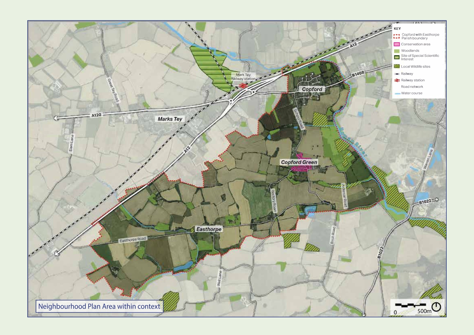
Copford Map of Neighbourhood Plan Area within context
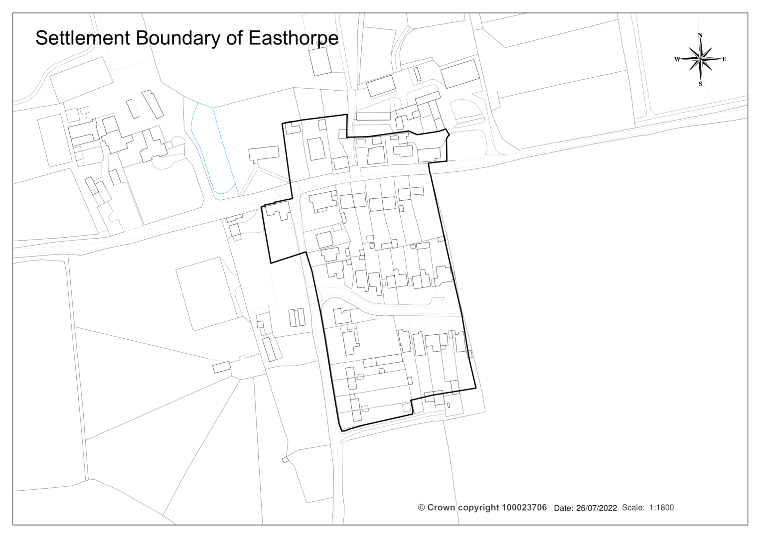
Settlement Boundary of Easthorpe

Settlement Boundary of Copford and Copford Green