Great Tey Neighbourhood Plan 2022-2033 (Regulation 16)
2 LOCAL CONTEXT
History of Great Tey parish[1]
2.1 For centuries Great Tey has been a farming community, with the main source of employment being on the farms across the parish. This was the case right up to the latter part of the 20th century.
2.2 Settlements have existed in Great Tey since before the Roman conquest of Britain, around 45 A.D. There is evidence of the use of Great Tey as an area for rest and relaxation for Roman soldiers from the Colchester garrison and remains of a Roman villa have been found close to what is now Tey Brook Farm.
2.3 Following the Norman invasion, the Domesday Book records Great and Little Tey in 1086 as being in the hands of Count Eustace of Boulogne. There were almost 40 households, representing quite a large settlement at that time.
2.4 At one time there were four pubs in the village, as well as two shops and all the services useful for a farming community.
2.5 It is thought that St Barnabas Church, which dates back to Saxon times, with additions in Norman times and later, was originally built using materials from the Roman villa. It remains an important and iconic building at the centre of the village.
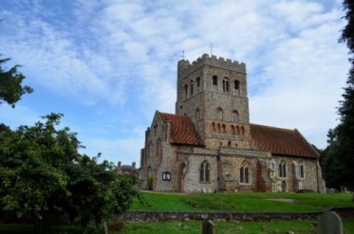
St Barnabas Church
2.6 The Old Playing Field is one of two playing fields in the village. It is accessed via The Chase and lies behind the Church. It has been in use as a playing field from well before 1727, when it was central to what was termed 'the Great Tey riot'.
2.7 Also along The Chase by the Church, was the Guildhall, that was converted to the parish Workhouse in 1752. Workhouses were designed to make the poor work for 'relief' but also to house the sick, orphans; the elderly and unmarried mothers.
2.8 The current Village Hall was built in 1926 by Reuben Hunt, who left a fund in trust in perpetuity for its upkeep and maintenance. The last major development in the village took place in the 1970s, doubling the area of the existing village, and leading to the new school being built. Since then, development has been organic, with new houses being built within the village envelope, although many dwellings have been extended and improved and other buildings have been converted to residential use.
Present day
2.9 Great Tey Parish today has around 400 dwellings and approximately 1,000 inhabitants. It extends as far as the A120 to the south and west, with small hamlets such as Broad Green on the western outskirts and a variety of other small settlements. The A120 has developed from the Roman Stane Street originally linking Colchester with St Albans but better known now as a link between the A12 and the M11, by Stansted Airport.
2.10 Many residents are commuters and use Marks Tey railway station to travel to work predominantly in Colchester, Chelmsford and London (see Figure 2.1).
Figure 2.1: Local context map
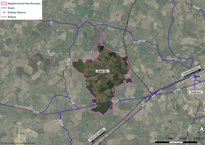
Figure 2.2: Listed buildings and conservation area - parish
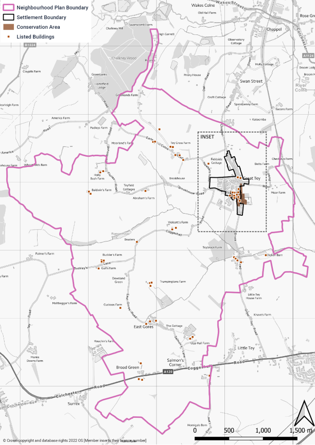
Figure 2.3: Listed buildings and conservation area – Great Tey village
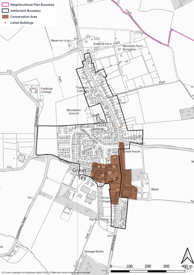
2.11 To the north the parish adjoins Chappel and Wakes Colne that has the A1124 running through it. However, the village of Great Tey is the principal part of the parish. The parish today has an eclectic range of dwellings, some with long histories, many without. There are 56 properties listed as being of historical interest and there is a conservation area as shown in Figures 2.2 and 2.3. There is a second playing field, the Harold Fairs Recreation Ground, which is located next to the school. It has a small children's playground and is used for football and cricket matches, and other recreation. Both areas are owned and maintained by the Parish Council. Nowadays there are 2 pubs, the Chequers in the village and the Kings Arms along the A120.
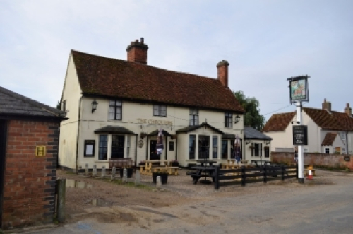
The Chequers Pub
2.12 The village school is thriving, although many of the children come from outside the village. The village has no shop, but a local refrigerated van comes around weekly, and is well supported.
2.13 The Village Hall is in constant use, providing a home for the local pre-school group, as well as hosting a number of clubs, societies and activities including children's and youth groups such as beavers, brownies, cubs, scouts and guides, the Women's Institute, and various special interest groups. An outreach Post Office service is available twice a week, on Tuesday and Friday afternoons. It is also frequently used for private hire for parties or events, mainly at weekends, and it is a polling station for elections.
2.14 There are 15 new houses along Brook Road, all occupied, and there is outline planning permission for 30 houses in New Barn Road. These are the two sites allocated in the now-adopted Colchester Local Plan Section 2.
2.15 The village is surrounded by farms and agricultural land where there is a network of bridle ways and public footpaths. These include a section of the Essex Way, reputed to have been an old drovers' road, linking the Essex coast near Harwich to Epping, a distance of approximately 80 miles altogether.
2.16 As well as farms and farm related businesses, there are four commercial areas and other small facilities providing employment within the Parish: at Tey Brook Farm and Warren's Farm on Brook Road; Upp Hall Farm on Salmon's Lane and the nearby East Gores Farm. These are mainly offices and workshops, primarily for a variety of local firms.
Points of interest
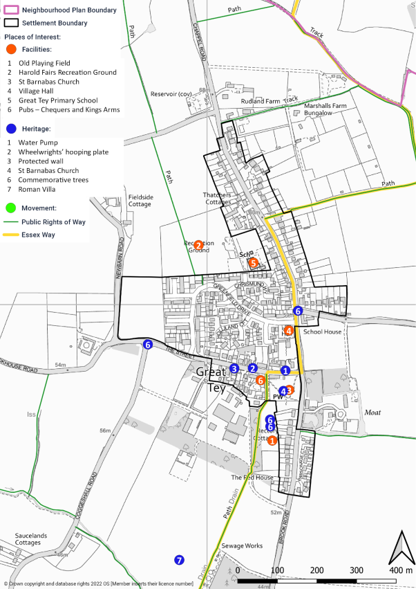
2.17 There are a number of points of interests of varying types in Great Tey, as shown in Figures 2.4 and 2.5.
Figure 2.4: Points of interest – parish
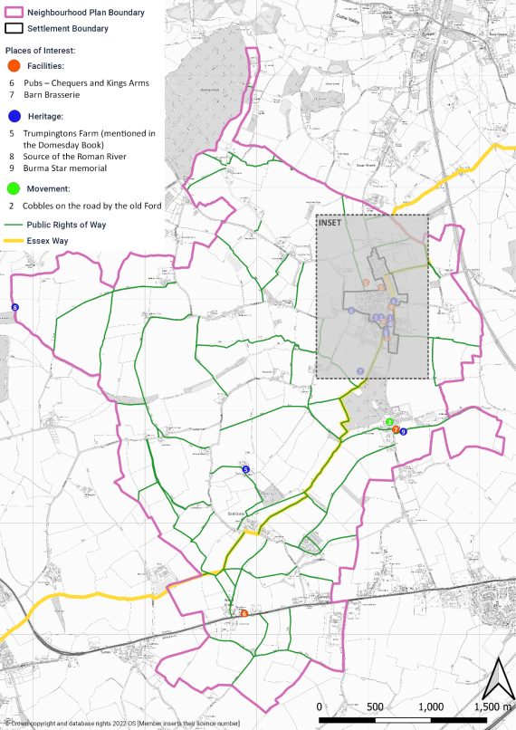
Figure 2.5: Points of interest – Great Tey village
Main issues and challenges in Great Tey
- Maintaining the 'best of Great Tey' – particularly the design of buildings and the rural feel, including the landscape and views.
- Access to the countryside – ensuring that Great Tey remains a small rural village where people can have easy access into nature.
- Poor connectivity – limited public transport.
- Light pollution – ensuring that the dark skies around Great Tey are not intruded by inappropriate lighting.
- Lack of local support services – including medical and post office counter services.
- Poor infrastructure – including water and sewerage.
[1] We are grateful to Dr Jane Pearson whose book 'Living in the Past Great Tey 1600-1900' has helped inform aspects of this section.