Myland & Braiswick Neighbourhood Plan Review
INTRODUCTION AND BACKGROUND
A Brief History of Myland and Braiswick
A History of the County of Essex: Volume 9 tells us that Mile End probably took its name from its original settlement a mile north of Colchester town. It had become a separate parish by 1254, when the original church was recorded, and presumably a settlement already existed. By the late 13th century it was sometimes called Myland. In the middle-ages settlement seems to have been scattered over the unwooded areas of the parish including Tubswick, recorded from 1295, and Braiswick which seems to have originated as a medieval freehold.
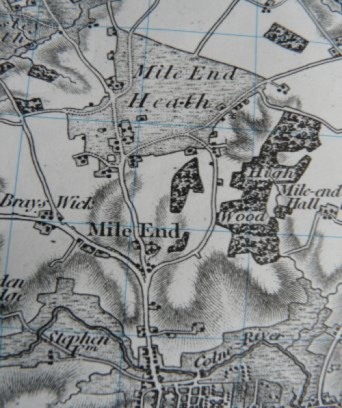
Much of Mile End was woodland and heath but much of that woodland had been cleared by the end of the 11th century. All of the parish was subject to royal forest jurisdiction. Kingswood included all of the parish except probably the part west of Nayland Road. The north part became the estate called Kingswood and Kingswood Heath, later known as the Severalls and Mile End Heath. Part of the south became the land of Mile End Manor. West of Nayland Road lay part of the ancient wood of Cestrewald or Chesterwell in the north; in the south was part of the Braiswick Estate.
There were potters living in the north-west of the parish in the 12th and 13th century. In the 17th century southern Mile End was used for fortified encampments and cannon sites for Oliver Crom-
well's troops during the Siege of Colchester. Nursery gardens became important in the 19th century. In 1801 the population was recorded at 299 and there were 44 houses. By 1901 the population increased to 1,373 with 300 houses largely influenced by the coming of the railway. Employment centred mostly on arable farming on cleared land. In February 1921 Colchester's first council houses were built in Defoe Crescent. The nineteen hundreds saw gradual expansion but the parish retained much of its rural feel. However, growth began to increase significantly late in the century with a population of around 6,000 by 1999.
Myland and Braiswick Today
The release of NHS and other land and the bisecting of Myland by the Northern Approach Road (NAR) to enable development of Cuckoo Farm has urbanised this once semi-rural part of Colchester Borough.
Since 1999 Myland Parish has undergone substantial change. This has accelerated in recent years to growth on an unprecedented scale. Based on recent and known future housing growth and applying the CBC formula of 2.33 persons per dwelling we can expect there to be a population well in excess of 21,000 by 2032. This is highly plausible with 2021 data revealing a population in excess of 17,000 with the Chesterwell development only about one third complete in 2022 and further residential dwellings planned at the Northern Gateway site. Such growth brings with it many changes that challenge sustainability of the area. From a semi-rural environment centred round Mile End Village and limited development in Braiswick the area will be a patchwork of diverse neighbourhoods. This transformation generates a number of issues that challenge economic, social and environmental sustainability.
This Plan therefore looks holistically across the area. Adjacent communities and settlements are also subject to areas of development and need to be considered when identifying the impacts of growth and the consequent needs of the community as a whole. Virtually all of the Plan Area is subject to agreed masterplans with the Northern Gateway developments the latest and expected to start in 2022. In Braiswick a number of small development areas were expected to be considered under an overarching masterplan but application approval at St Botolphs Farm has undermined this.